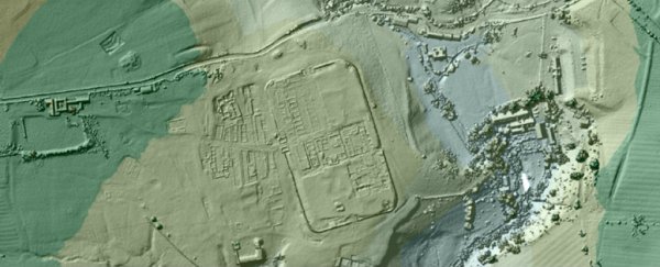
British archaeologists have discovered long-buried roads built by Roman settlers in the 1st century AD, using an advanced laser light technology called Lidar ("light" and "radar") to uncover all kinds of secrets about the centuries-old transport infrastructure.
The discovery is now giving historians the chance to piece together how Roman legions conquered and mapped out areas of Northern England from 43 AD. "Previously in Lancashire we only had aerial photographs from the 1940s and 1960s to go on, but with photographs features only show up after a drought and we don't get many of those," said one of the team, David Ratledge from the UK Environmental Agency. "With Lidar, once you know what to look for, it's blindingly obvious - you just know you've found a road… It's been revolutionary."
First invented in the 1960s, Lidar technology makes use of ultraviolet, visible, or near infrared light to map objects in a very high resolution, and it can detect a wide range of materials, even down to single molecules.
It's similar to sonar (using sound waves) and radar (using radio waves), but uses light lasers instead. By measuring how this light bounces back (from an aeroplane, for example) the height and position of objects below (such as trees and mountains) can be accurately ascertained.
As the British government makes its Lidar data public, amateur enthusiasts will be given the opportunity to look for hidden treasures that don't fall under the original remit of the technology.
Although Lidar can't see objects buried underground, it can spot subtle indentations in the landscape, giving historians the clues they need to spot roads that would otherwise be invisible in standard photos and maps.
After 2,000 years of weathering, Roman roads in England can now be very difficult to spot without Lidar. "The preservation of the remains varies massively," says Ratledge. "Parts of a road could still be half a metre high and easy to spot whilst in other parts it could be so subtle that you'd definitely miss it on the ground."
Five 'lost' roads have been found so far, with other potential routes still being verified through fieldwork on the ground. By combining the Lidar data with what clues are left in the landscape itself, archaeologists will have a much better chance of being able to confirm where the Roman highways once lay.