It's been 37 years as of last Thursday since the Mount St. Helens volcano in the US state of Washington exploded, taking 57 lives and destroying hundreds of square kilometres of forest, bridges, and homes.
The US Geological Survey (USGS) has been keeping an eye on the volcano's activity ever since, and says while it's unlikely we have much to fear at the moment, recent quakes are a reminder that the bomb under the mountain is slowly recharging.
Geologists Liz Westby from the USGS explained to the ABC how some small but unusual clusters of tremors aren't anything to worry about.
"Mount St. Helens is at normal background levels of activity," Westby told the ABC's Blair Shiff.
"But a bit out of the ordinary are several small magnitude earthquake swarms in March to May 2016, November 2016 and April 16 to May 5, 2017. During the April 16 to May 5, 2017 swarm, we detected well over 100 earthquakes, all below a magnitude 1.3."
None of these quakes are big enough to feel on the surface, and they don't coincide with surface activity like venting of gases or surface deformation, so the geologists aren't raising any alarms.
Yet nearly four decades after the devastating 1980 eruption, the odd rumblings should serve as a warning on how much we rely on scientists like those at the USGS to keep us vigilant.
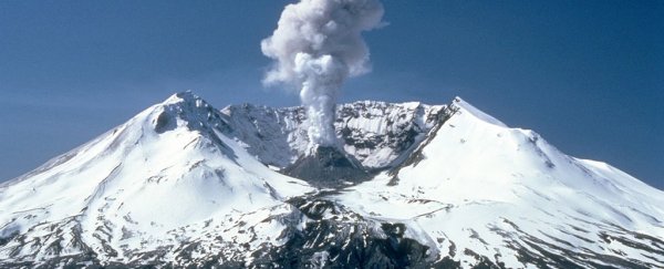
The swarms of quakes are signs of the magma chamber beneath the mountain refilling, something that has been happening since it finished its last eruption in 2008.
"This is why we maintain a close watch over these giants, so we can detect the earliest signs of reawakening," Westby said.
At about 8:30am on Sunday, 18 May, 1980, a 5.1 magnitude earthquake caused the entire north face of the Mount St. Helens volcano to slip away in the largest observed landslide in recorded history.
Hot gases, molten snow, and steam combined with soil and rock in a wave that ripped across the land at nearly 500 kph (more than 300 mph). When it was over, the mountain was about 400 metres (1,300 feet) shorter.
The countryside was turned into a wasteland. Hundreds of homes were destroyed, along with scores of bridges, and more than 300 kilometres (about 200 miles) of roads.
In all the volcano caused over a billion dollars US in damage, yet most tragic of all were the 57 deaths caused by the event, including a USGS geologist.
For such a devastating eruption, the volcano had been rather quiet for the past century, showing few signs of activity since the middle of the 19th century.
In the 1970s USGS researchers noticed the ash and lava flows in the mountain painted a picture of frequent activity, leading to a report being published in 1978 warning the mountain could be "especially dangerous" if it's history is anything to go by.
Two years later the world would learn just how dangerous.
"On the afternoon of March 20, [1980], a 4.0-magnitude earthquake took place at Mount St. Helens, and I immediately recognized that as something of interest," Stephen Malone from the University of Washington told Ashley Williams at AccuWeather.
An eruption followed a week later, and geologists moved in to study the volcano. While the numbers of quakes decreased over the next few months, the size of tremors grew.
"So, we were convinced this was not over," said Williams.
A great deal has been learned about volcanoes in general and the geology beneath Mount St. Helens since, with the Cascades Volcano Observatory recording data and keeping watch.
That's not to say there are no mysteries still to solve, especially since the volcano sits in a rather odd place with respect to the Cascade Arc of volcanos running from California to British Columbia.
But when Mount St. Helens erupts again, and it will, those in its path will be better prepared than they were nearly 40 years ago.