A surge of frigid air is barreling across the eastern half of the nation, unleashing snow and, in many locations, the coldest weather on record for this time of year.
The National Weather Service is calling it "the coldest surge of arctic air so far this season," predicting 385 cold records to fall from the Plains to the East Coast through Wednesday.
In many locations, temperatures have bottomed out or will drop to 15 to 30 degrees Fahrenheit below average. For tens of millions, the cold will barge in suddenly, with temperatures plummeting 30 degrees F in 12 hours or less.
In Dallas, the temperature crashed 19 degrees F in a single hour Monday as the Arctic front moved through, from 65 to 46 F (18 to 7 degrees Celsius) between 10 am and 11 am local time, as winds gusted to 44 mph (70 km/h). Lows are predicted to drop into the 20s there on Monday night.
Ever wondered what an Arctic Blast really looks like? The next 24 hours over Texas and Louisiana is it... #lawx #txwx pic.twitter.com/oeGNNnaYZ5
— Zack Fradella (@ZackFradellaWx) November 11, 2019
The cold first invaded the northern Rockies on Sunday. In Havre, Mont., the mercury tanked to a record low of -18 F (-27 C) on Sunday. Then, on Monday, temperatures in northern Montana fell as low as -30 F (-34 C).
The cold is rapidly expanding southeast and will even reach the zone from Galveston, Texas, to the Florida Panhandle along the Gulf Coast. By Wednesday morning, almost the entirety of the eastern half of the Lower 48 will see freezing temperatures, except for the Florida Peninsula.
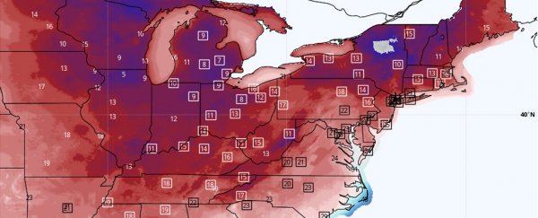
 Forecast lows for Wednesday (The National Weather Service)
The snow
As the Arctic front plows eastward, it is producing a wide swath of accumulating snow on its backside from the Midwest to the Appalachians, where winter weather advisories are in effect.
Amounts of 1 to 4 inches (2.5 to 10 centimetres) are predicted to be most widespread from the Midwest to the Northeast, but some areas downwind of the Great Lakes could receive one to two feet (even localized totals to 30 inches; 76 centimetres) by midweek, thanks to the Arctic air blowing over the comparatively mild lake waters.
In Chicago, O'Hare International Airport reported snow, 22 F, wind gusts to 30 mph, and visibility of a half-mile at 9 am local time Monday. The slick conditions caused an American Airlines flight to skid off the runway.
BREAKING: @AmericanAir Flight AA4125 from @flyfrompti to @fly2ohare slides off runway in Chicago this morning. Passengers tell me everyone is OK, deplaned and on buses to terminal. Video: Joseph Lian from Greensboro. @ABC11_WTVD @ABC #ABC11 pic.twitter.com/rBwyqfVtiU
— Andrea Blanford (@A_Blanford) November 11, 2019
Chicago is under a winter weather advisory until 2 pm Monday, with several inches of snow predicted to be followed by a frigid night, with low temperatures near 10 F.
The early onset of cold, snowy conditions is allowing ski resorts in the Northeast to open early. For example, Mount Snow in Vermont announced it will open Wednesday, while Hunter Mountain Resort in New York will have its lifts running Friday.
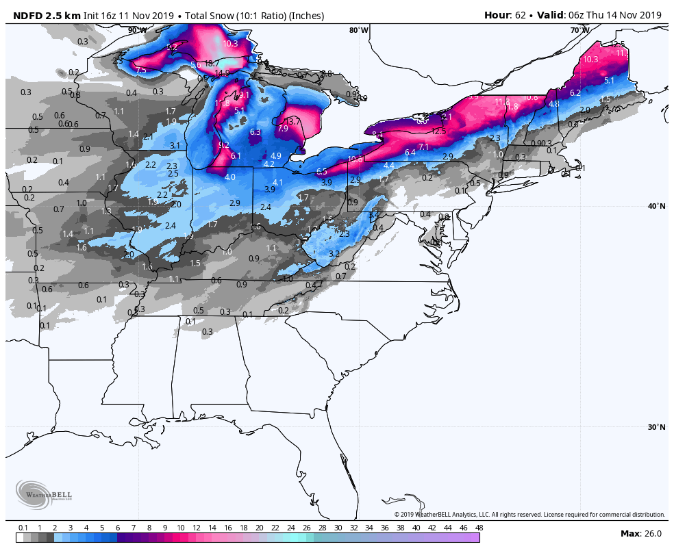 Forecast snowfall for Wednesday. (WeatherBell.com)
Record cold
Monday
Highs are forecast to reach only the teens in the Dakotas and Minnesota on Monday, with highs in the 20s F in Nebraska, Kansas, Iowa, Wisconsin and Michigan.
In Minneapolis, the forecast high in the mid- to upper teens on Monday is likely to be the coldest on record for the date, lower than the previous record of 19 F.
High temperatures are predicted to remain below freezing as far south as the Texas Panhandle, northern Oklahoma, and central Missouri and Illinois.
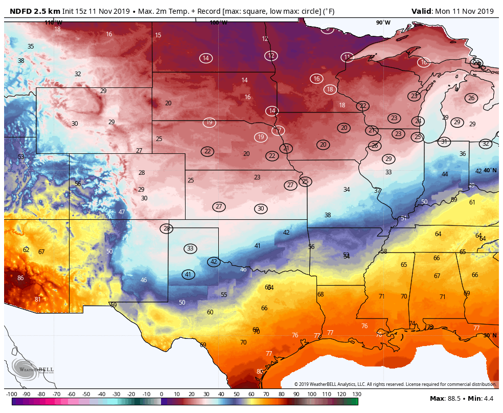 Forecast highs on Monday, with near record lows circled. (WeatherBell.com)
Tuesday
Single-digit lows are predicted in Nebraska, Iowa, northern Illinois and points north, with a few spots falling below zero. Lows in the teens are expected as far south as northern Texas and Arkansas.
Forecast highs on Tuesday should remain below freezing over more than half of the eastern Lower 48 states, from interior New England to as far south as Tennessee and as far west as eastern Nebraska and Kansas.
Record-cold highs on Tuesday are predicted to be widespread from near the central Gulf Coast (highs in the 40s F) through the Tennessee and Ohio valleys (highs in the 20s and 30s F) and into the eastern Great Lakes and interior Northeast (highs in the 20s F).
New Orleans, Nashville, Chicago, Detroit, Cincinnati, Cleveland and Buffalo could have their coldest highs on record for November 12.
Chicago is forecast to have a high of 25° on Tuesday. Last year the high did not get colder than 25° in November OR December. The same can be said about the forecast of 28° in St. Louis and Cincinnati and 40° in Dallas.
— Maxar | WeatherDesk (@Maxar_Weather) November 7, 2019
In Houston, forecast highs Tuesday are expected to be in the mid-40s F after reaching the mid-70s F on Monday. New Orleans will see a similarly precipitous drop.
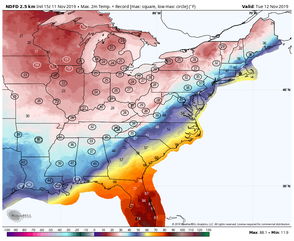 Forecast highs for Tuesday, with near record lows circled. (WeatherBell.com)
Wednesday
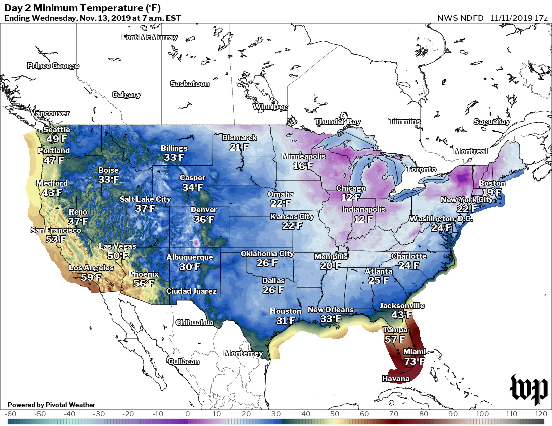
Forecast lows across much of the eastern third of the nation are likely to be in record territory early Wednesday. Widespread temperatures in the teens are expected from northern Alabama and Mississippi northeast through New England. The Mid-Atlantic and Southeast are predicted to dip into the 20s F.
Forecast highs will recover into the 20s and 30s F in the Northeast and Mid-Atlantic, with 40s to near 50 F in the Southeast.
"Bitterly cold conditions will persist for this time of year," wrote the Weather Service office serving the Washington and Baltimore region, where highs are forecast to reach only the mid- to upper 30s F Wednesday after reaching the mid-60s F on Monday.
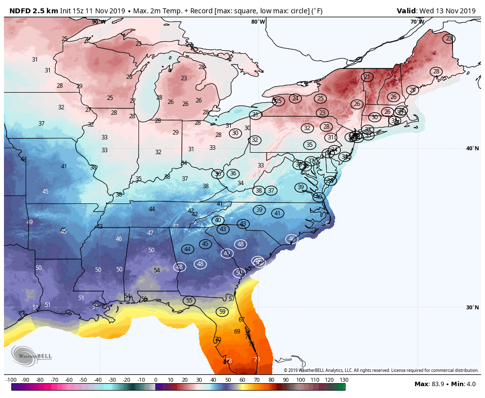 Forecast highs for Wednesday, with near record lows circled. (WeatherBell,com)
When is relief coming?
The intensity of the cold will ease during the second half of the week across the eastern half of the nation, but, in most places, temperatures will generally remain below average.
The Weather Service's 6-to-10-day outlook favors below-average temperatures in the eastern third of the nation.
Leading into Thanksgiving, however, milder air may return, as the Weather Service's 8-to-14-day outlook leans toward average to milder-than-average conditions.
2019 © The Washington Post
This article was originally published by The Washington Post.