Archaeologists in Peru have made a stunning discovery: over 50 previously unknown Nazca lines - and some of them are centuries older than the most famous of these magnificent desert drawings.
Most of these mysterious geoglyphs were created by the Nazca people, who lived in the area from 200 to 700 CE. But the researchers believe that some of the newfound ones were created even earlier - by the Paracas and Topará people, who lived there around 500 BCE to 200 CE.
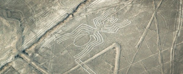
The lines have been a source of fascination and wonder for decades. Created by pushing aside the top layer of red desert pebbles to reveal the pale layer underneath, these geoglyphs span vast tracts of the Nazca Desert, between the towns of Nazca and Palpa.
Some of them form geometric shapes, some are simple lines, and some are combined into elaborate depictions of animals and objects.
The most wondrous thing about these ancient symbols is that you often can't see what they depict from ground level. You have to get up in the air to discern the patterns, which is why their full glory wasn't understood until after the invention of airplanes.
The earlier Paracas glyphs, on the other hand, were often laid down on hillsides, which means that, from the right perspective, they can be seen by people on the ground. They also often depicted humans, in contrast to the more geometric Nazca shapes.
Most of the newly discovered Paracas figures depict warriors, and they predate the Nazca lines by centuries. You can see their glory in this video from National Geographic:
"This means that it is a tradition of over a thousand years that precedes the famous geoglyphs of the Nazca culture, which opens the door to new hypotheses about its function and meaning," archaeologist Johny Isla of the Peruvian Ministry of Culture, who is in charge of restoring and protecting the lines, told National Geographic.
When a 2014 Greenpeace protest near the famous hummingbird glyph damaged the UNESCO-protected area, Isla and his team received a grant from the US government to aid in this important work.
But because the maps are so patchy, this work can be difficult, so Isla teamed up with Luis Jaime Castillo Butters, a professor of archaeology at the Pontifical Catholic University of Peru, to fill out these maps.
They worked with National Geographic Explorer and archaeologist Sarah Parcak, who founded the GlobalXplorer initiative. Like Zooniverse, this "crowdsources" science, recruiting citizen scientists to look through satellite imagery to find locations of potential interest - in the case of Peru, potential archaeological sites, or instances of looting.
After the initial survey, Castillo physically visited the sites, finding little of interest.
Then, the team imaged the sites with drones, using both photography and 3D scanning - and revealed dozens of geoglyphs nobody had noticed before.
Degradation and erosion over time had hidden these lines from view - but with drones, which are more lightweight, affordable and accessible than planes, they were discovered anew.
Although the new glyphs fall within the UNESCO-protected site between Nazca and Palpa, they have yet to be registered with the Peruvian Government. But they're not under immediate threat - and the GlobalXplorer citizen scientists are continuing to find sites of interest, which, if they turn out to be significant, may expedite registration.
Meanwhile, satellite data can help protect the glyphs from unplanned human encroachment, which is one of the biggest threats they face - truck drivers notwithstanding.