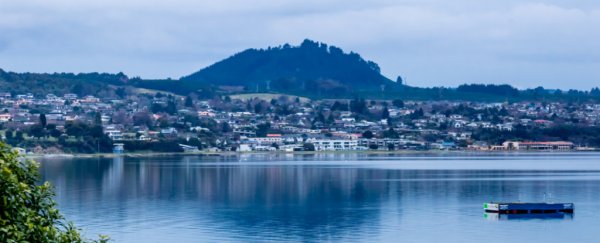
The vast expanse of Lake Taupō's sky blue waters, crowned by hazy, mountainous horizons, invokes an extreme sense of tranquility.
And yet, deep in the ground below, geological unrest is brewing, according to a new paper in the New Zealand Journal of Geology and Geophysics.
Lake Taupō is the largest freshwater lake in Australasia, located at the center of New Zealand's north island. And while it appears peaceful today, the lake has a violent origin story.
The lake's waters sit within a prehistoric caldera – a word based on the Spanish for 'cauldron' or 'boiling pot' – formed during Earth's most recent supereruption, the Oruanui eruption, 25,400 years ago.
When magma is released from a supervolcano (defined as having released at least 1,000 cubic kilometers of material in any one eruption) in an event like the Oruanui eruption, the depleted magma vents cave in, Earth's surface sinks, and the landscape is permanently changed into a caldera.
In the last 12,000 years, the Taupō volcano has been active 25 times. Its most recent eruption in 232 AD is described by authors of the new paper as "one of the Earth's most explosive eruptions in historic times". Since then, the volcano has had at least four documented "episodes of unrest", causing destructive earthquakes and, in 1922, a massive ground subsidence.
It's the supervolcano's more modern periods of unrest that the researchers have studied, analyzing up to 42 years of data collected at 22 sites dotted around and across the lake. And there's evidence that the supervolcano is still rumbling.
"In 1979 [researchers] began a novel surveying technique which uses the lake surface to detect small changes, with four surveys made every year since," lead author and Victoria University of Wellington seismologist Finn Illsley-Kemp explained. This technique involves the use of a gauge that measures vertical displacement of the lake bed.
To ensure the data are reliable, these gauges are weighted to reduce the impact of waves, and several measurements are taken for each datapoint, to detect degrees of variation and outliers. A backup gauge is also installed at each site as an insurance against disturbance by other forces.
In the project's beginning, the measurements were recorded from manual gauges set up at just six stations. Eight more stations were added between August 1982 and July 1983, and during this time, the value of these measurements began to show.
In early 1983, the system detected rising or falling across different sites. Not long after, a swarm of earthquakes gently shook the region, resulting in the rupturing of several faults that pushed the central Kaiapo fault belt down and caused other areas at the lake's south end to rise.
The 1983 earthquake swarms were only the first of seven discreet episodes of unrest recorded over the past 35 years.
By 1986 routine surveys were being carried out each year with additional sensors, with extra observations in the wake of earthquakes, creating a robust dataset that has only become more detailed over time.
The authors noticed that during periods of geological unrest, the north-eastern end of the lake (which is closest to the volcano's center and the adjoining fault lines) tended to rise; the lake bed near the fault belt's center sank; and at the lake's southern end, there was some minor subsidence.
"Within the lake, near Horomatangi Reefs, the volcano has caused 160 mm [16 cm or 6.3 inches] of uplift, whereas north of the lake the tectonic faults have caused 140 mm [5.5 inches] of subsidence," Illsley-Kemp said.
He thinks this region, which has very few earthquakes compared to the surrounding areas, is the location of Taupō 's magma reservoir, with deep rock that is too hot and molten for earthquakes to occur.
The researchers say the 16 cm of uplift – which, while not catastrophic, is definitely enough to cause some damage to buildings or pipes – is possibly due to magma moving closer to the surface during periods of unrest.
Illsley-Kemp said the research shows Taupō is an active and dynamic volcano, intimately connected with the surrounding tectonics.
The researchers think the northeastern end of the volcano – which has the youngest vents – is more likely to be affected by the expansion of hot magma, pushing the ground upwards. They think the 'sinking' center of the Taupō fault, and the subsidence at the lake's southern end is likely due to deep magma cooling (and therefore shrinking), a tectonic extension of a rift, or both.
Illsley-Kemp has regularly assured people that while it's in a state of unrest, there is no evidence the volcano will erupt anytime soon.
"However, Taupō will most likely erupt at some stage over the next few thousand years – and so it's important that we monitor and understand these unrest periods so that we can quickly identify any signs which might indicate a forthcoming eruption," he told the New Zealand Herald in a 2021 article.
Ultimately, this research is more about understanding the normal 'behavior' of the caldera, and what to look for when things are getting more heated.
This study is published in the New Zealand Journal of Geology and Geophysics and Geophysics.