The worst case scenario for sea level rise in the United States is more than just a dim possibility. It's becoming more likely.
An annual "report card" for the US coastline shows sea levels are speeding up in most places measured.
"Acceleration can be a game changer in terms of impacts and planning, so we really need to pay heed to these patterns," says John Boon at William and Mary's Virginia Institute of Marine Science (VIMS).
Out of the 32 tidal stations monitored from Maine to Alaska, the team detected sea level rise in no less than 27. What's more, 25 of those locations experienced higher rates of sea level rise in 2019 than in the year before.
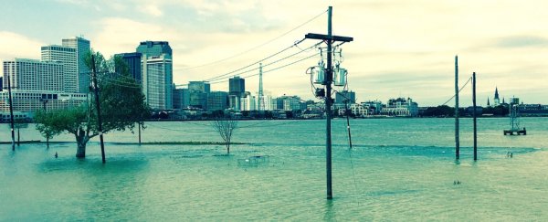
The Gulf Coast in Louisiana, and Galveston and Rockport in Texas were at the very top of the list. In fact, Rockport trumped all 32 stations, exhibiting a rate of sea level rise that the authors say would ultimately leave water levels 0.82 metres higher in 2050 than in 1992.
In the end, only five stations around the country experienced falling sea levels, four of which are located in Alaska, where coastal mountains are in the process of forming (whereas, on the east coast, land is generally busy sinking).
"Although sea level has been rising very slowly along the West Coast," says marine scientist Molly Mitchell, "models have been predicting that it will start to rise faster. The report cards from the past three years support this idea."
It's not just the team at VIMS, nor is it just the US experiencing this. The National Oceanic and Atmospheric Administration (NOAA) thinks sea level rise is accelerating around the world, and it's been doing so since around 2013 or 2014.
In a 2017 report of sea level rise scenarios, experts at the agency predicted that even if our emissions stayed low, global sea levels would very likely rise at least 0.3 meters (12 inches) within a century.
If emissions grew, on the other hand, the waters could rise by as much as 2.5 metres (8.2 feet) by 2100.
Three years after this prediction, Mitchell has bad news.
"Seeing acceleration at so many of our stations suggests that - when we look at the multiple sea-level scenarios that NOAA puts out based on global models - we may be moving towards the higher projections," she claims.
In 2017, these higher projections were 2.5 metres by 2100, 5.5 metres by 2150 and 9.7 metres by 2200.
The acceleration is being driven mainly by increased melting in Greenland and Antarctica, experts claim. Together, these land masses have the ability to double the total sea level rise by 2100; today, Greenland is losing more than seven times as much ice each year as it did in the 1990s.
Under the current rate, NASA and European data indicates the world's oceans could rise 0.65 metres (26 inches) by the end of the century. And researchers think this is probably conservative.
"Our extrapolation assumes that sea level continues to change in the future as it has over the last 25 years," said a member of NASA's Sea Level Change team at the time.
"Given the large changes we are seeing in the ice sheets today, that's not likely."
If sea levels continue to accelerate, the risk of saltwater infiltration, flooding and storm surges will only grow worse, as will the likely displacement of hundreds of millions of people around the world.
So far, our predictions for sea level rise, such as those from the Intergovernmental Panel on Climate Change (IPCC), have tended to underestimate the problem, especially given recent acceleration. But with the reality speeding towards us, we might not be able to do so for much longer.
The sea level report card can be accessed on the VIMS website.