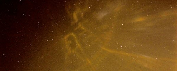
In the Finnish town of Eura last week, if you wanted to know where to go, all you had to do was look to the sky for directions. Thanks to the super-cold winter temperatures, the glow from streetlights began bouncing off ice crystals in the air, producing an atmospheric phenomenon known as light pillars, stretching up to the sky.
Light pillars themselves aren't that rare, they're often seen from the side, creating beautiful, luminous towers of light. But on January 12, photographer Mia Heikkilä was lucky enough to be standing among a whole bunch of light pillars in her neighbourhood, Kauttua, allowing her to see their trips from below. And she quickly realised that they were forming a familiar pattern. "There was a street map of Kauttua painted in the sky!" Heikkilä told SpaceWeather.
"It was an exact reversed light map of Kauttua, Eura, created by light pillars," Heikkilä explains.
So how is that possible? When the temperature gets close to freezing, flat, hexagonal ice crystals can form in the air – not just up high, but also close to the ground. When this happens, these crystals essentially form a collective, giant mirror that can reflect a light source - such as a streetlight - back to the ground.
That seems counterintuitive, because light pillars stretch up into the sky. But the light has been reflected back down to Earth because it hits the flat bottom of the ice crystals on its way up, which is why we're able to see it at all. This creates the illusion of a pillar climbing upwards. "In reality, we're only seeing it because it got knocked back down to us," writes Esther Inglis-Arkell for io9.
Light pillars are an optical phenomenon that belongs to the halo family, which means it's caused by the interaction of light with ice crystals. But unlike other types of halos, such as sun dogs, the light is being bounced straight back down to us, rather than to the side.
When enough of these light pillars form in a small area, as has happened in Kauttua, the reflected light can create a reverse image of the streetlights below, appearing to someone standing on the ground as thought it's being projected right into the sky.
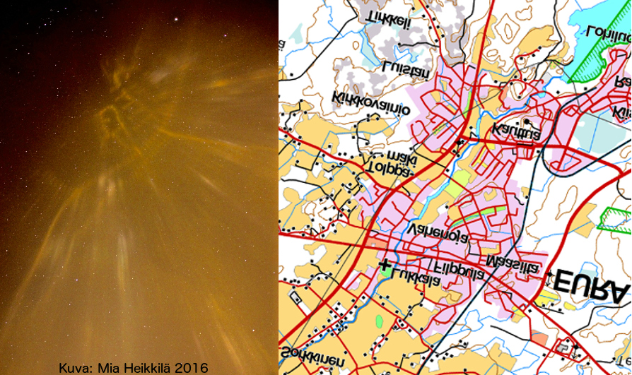
In this case, those lights produced a pretty accurate map of the streets below. You can see the comparison between the real reverse map of Kauttua and Heikkilä's photograph below:
 Mia Heikkilä/SpaceWeather
"In fact, the sky map was even better than the printed map Heikkilä used for comparison, because it traced the most recent changes to the cityscape," writes SpaceWeather.