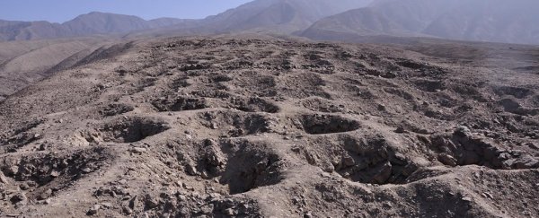
Marks of human activity left on the landscape can give us clues about how our ancestors lived hundreds, even thousands, of years ago, and the latest bizarre construction under scrutiny is a mile-long strip of land in Peru, covered in a series of mysterious shallow holes.
Two archaeologists now think this so-called Band of Holes could actually be part of an ancient Inca tax system, with the rock-lined pits used to measure and then redistribute food. We know this kind of tribute system was already in place, thanks to journals written by early European visitors to South America, so is this the final piece of the puzzle?
The hypothesis is being put forward by Charles Stanish and Henry Tantaleán from the University of California, Los Angeles, who are using drone technology to map the site. In fact, it's thought that the pattern of holes was first discovered thanks to aerial photography, with the first snap recorded from the sky in 1931.
Stanish and Tantaleán point to the trail's location close to a well-known Inca highway, Annalee Newitz from Ars Technica reports, and there's also the remains of Inca pottery and a storeroom (called a "colca") not too far away.
These colcas were used by the Inca people to store food and textiles and distribute them out among the people, which was an early version of a tax system, with the wealth of a nation being shared between the authorities and the people in need. Since colcas used grids drawn on the floor to measure goods, Stanish and Tantaleán think the Band of Holes is a similar sort of set-up, but more out in the open.
The holes themselves, which have been dated to the 15th century, are not particularly uniform, with each one about 3 feet (0.91 metres) wide and 20 to 40 inches (51-102 cm) deep. The holes aren't hollowed out of rock, but have been constructed by mounding soil and piling rocks, which still would have required a lot of effort.
Stanish and Tantaleán started examining the site in detail in 2015. They found different types of holes separated out into blocks, and used drones fitted with cameras to map the position of more than 5,000 depressions – a construction the archaeologists suspect could have taken 100 workers about a month to build.
Stanish says teams working on colca excavations "had a really good explanation" for how the squares were used to measure tribute. "It seemed likely to me that the holes at [Band of Holes site] Monte Sierpe could have been used to measure out tribute as well," he told Eric A. Powell at Archaeology Magazine.
"It's the perfect place to stop, measure your produce, and make sure you have the proper amount of tribute," adds Stanish.
As with every odd-looking discovery some have speculated the strip of holes had been left by aliens, writes Powell, while others have suggested that it could be a trail marker, a defensive structure, or a geoglyph (a large motif etched into the landscape).
The archaeologists want to study the area further in order to find traces of maize, beans, squash or peppers, which would confirm their hypothesis. Right now, not everyone agrees with Stanish and Tantaleán about what these holes were used for, but additional research could be enough to prove that it really was a rudimentary system for measuring taxes.