Hundreds of thousands of kilometres of submarine cables lying on the ocean floor - sometimes at depths nearing 8,000 metres - are essential for powering the modern Internet, transmitting 99 percent of all international data.
As Phil Edwards explains for Vox, "The cables are so widely used, as opposed to satellite transmission, because they're so reliable and fast: with high speeds and backup routes available, they rarely fail. And that means they've become a key part of the global economy and the way the world connects."
TeleGeography, a US based telecommunications market research firm, has already created some impressive maps depicting these cable networks. But now they've added a beautifully illustrated, vintage-themed map to the collection, which looks like it's been plucked straight from the Renaissance period.
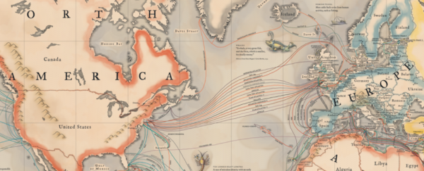
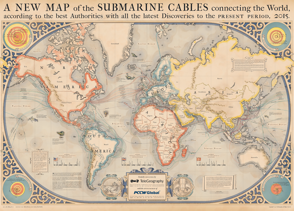 The Internet's underwater cables (Credit: TeleGeography)
"This year's map pays tribute to the pioneering mapmakers of the Age of Discovery, incorporating elements of medieval and renaissance cartography," the company states on its website. "In addition to serving as navigational aids, maps from this era were highly sought-after works of art, often adorned with fanciful illustrations of real and imagined dangers at sea. Such embellishments largely disappeared in the early 1600s, pushing modern map design into a purely functional direction."
"To bring back the lost aesthetic that vanished along with these whimsical details, TeleGeography referenced a variety of resources in the design process," they add. "One of the most invaluable was Chet Van Duzer's Sea Monsters in Medieval and Renaissance Maps book, which provides arguably the most complete history of the evolution of sea monsters and map design from this period. Our final product is a view of the global submarine cable network seen through the lens of a bygone era."
The map shows the paths of 278 functional submarine cables, as well as a further 21 cables that are planned or under construction. Since 2010, these cables have linked all of the world's continents, except Antarctica - where research stations still rely on satellite Internet.
The map highlights the speed, in milliseconds, at which information is transmitted between certain countries, and also illustrates the "lit capacity" of each cable. This is how much traffic a given network can handle, and is usually measured in terabytes of data.
The map is also adorned with illustrations depicting the laborious process of laying these cables, which have variable sizes depending on depth, as well as common causes of cable faults.
As David W Brown explains for Mental Floss, "the cables are installed by special boats called cable-layers. It's more than a matter of dropping wires with anvils attached to them - the cables must generally be run across flat surfaces of the ocean floor, and care is taken to avoid coral reefs, sunken ships, fish beds, and other ecological habitats and general obstructions".
In shallower waters, down to about 1,000 metres, these ships drag an underwater plough that creates a groove in the seabed where the cable will sit. Afterwards, currents will push sand overtop, essentially burying the cables.
Seismic activity is also a consideration for route planning, as underwater earthquakes could damage cables. Damage could also be inflicted by fishing trawlers, anchors, curious sharks, or else sabotage - as is suspected of happening in Egypt in 2013.
For the sake of all our Internet-viewing pleasure, let's hope our cables continue functioning at full capacity. And in the meantime, we can enjoy the amazing underwater infrastructure that supports our surfing with this map.
Sources: TeleGeography, Vox, Mental Floss