California has been in the grip of drought for more than five years now.
While there are promising signs that this horrid dry spell might soon be at an end, it's too early to celebrate it officially. Not that the state's wildflowers have a clue – they're throwing a party so big that satellites have been snapping mementos.
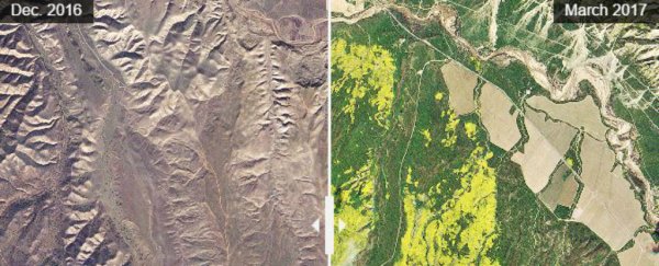
After a recent drenching at the close of what promises to be the second wettest December to February period since records began, the official floral emblem – the California poppy (Eschscholzia californica) – went nuts and bloomed in numbers so big satellite imagery could easily detect the changes in vegetation.
Check out the difference between the Carrizo Plain National Monument this year and last year below:
 Planet Labs via Washington Post
The cause of California's extensive drought has been blamed on a massive high pressure zone several thousand kilometres (roughly 2,000 miles) long sitting stubbornly off the west coast, what one meteorologist has called a "ridiculously resilient ridge".
It's the not the first time this mountain range of high pressure has parked itself there, causing a similar drought over two years in the late 1970s, but it is the worst.
In 2015, California's governor Jerry Brown announced a state of emergency and imposed a strict water conservation plan and assistance for farmers.
He also put into action a plan to desalinate sea water to add fresh water to the rapidly depleting reservoirs, something which would be a boon for the state but could pose environmental problems as the leftover salty brine was pumped back out to sea.
Now the water reserves are filling up as the skies open and the snowpack begins to melt, but before we can say the drought is at an end, there's three things that need to be considered:
- Surface water: 2017 has provided plenty of rain to trickle into the state's dams water reservoirs, filling them to above-average levels.
- Snowpack: The snow coating the Sierra Nevada supplies about 30 percent of California's water needs. While it's looking good for the summer ahead with above average snowpack, it all comes down to temperature – if it melts too quickly, the state can expect floods rather than a steady supply of water.
- Groundwater: Aquifers are where we suck water from when the surface supply shrinks, but it also takes a long time to replenish, meaning California could need to wait a few years for its groundwater reservoirs to return to previous levels.
California poppies don't need to be told to hold on and wait for government surveys, however – the hardy little desert plant (considered by many to be a weed given how it can hold on while others die of thirst, and bloom back quickly with just a sip of water) has put on quite a show with the rains.
The plant isn't big, growing about 30 centimetres (12 inches) long with typically orange petals that open in sunlight and close at dusk.
But collectively, the flowers bloom in vast fields that are regarded by nature-loving visitors as an annual must-see event.
Sadly, the plants can suffer from this tourism love-fest as eagre flower fans trample over the plants to get that 'perfect selfie'.
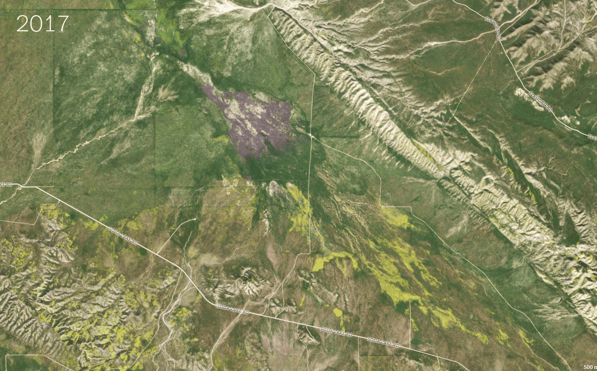
If you're a local and feel like a drive to take a shot or two yourself, Washington Post recommends heading to Carrizo Plain in the southern Central Valley before the weather warms, where you'll not just find fields of the poppies but also see the dust-bowl of Soda Lake once again filled with water.
Failing that, Los Padres National Forest is also reportedly putting on a show, or you can take a long-distance snapshot of the hills of Bitter Creek National Wildlife Refuge from Hudson Ranch Road, which runs through the park.
For the rest of us, we can appreciate the botanical fireworks through the eye in the sky in the pictures below, as we take a celebratory sip of water and hope the drought might finally be at a close for our friends and family in California.
These satellite images were taken by Planet Labs - a start-up founded by three ex-NASA engineers. Use the vertical slider to compare side-by-side images, via KQED Science.
Near Los Padres National Forest
Carrizo Plain National Monument
Bitter Creek National Wildlife Refuge