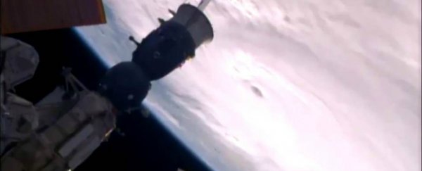
NASA has just released footage of Hurricane Matthew captured from the International Space Station, and it puts into perspective just how intense this Category 4 storm really is.
The hurricane spent the weekend brewing over the Atlantic just south of Haiti and Jamaica, before heading north and hitting Haiti late on Monday night, with devastating winds of up to 220 km/h (140 mph) and "life threatening" rain - one person has reportedly already been killed by the storm.
The footage below has been sped up four times, and was captured by cameras outside the International Space Station on Monday morning, showing the orbital complex of the storm from 400 km (250 miles) above. It's pretty terrifying - that huge white cloud is all Hurricane Matthew.
Cameras outside the space station captured dramatic views of major Hurricane Matthew as the orbital complex flew 250 miles above (speed x4). pic.twitter.com/nfAQuw2OQC
— International Space Station (@Space_Station) October 3, 2016
In addition to the gail-force winds, Hurricane Matthew is predicted to bring up to 100 cm (40 inches) of rain to Haiti and the southwest Dominican Republic, which could trigger "life threatening flash floods and mudslides", according to the US National Oceanic and Atmospheric Administration (NOAA).
There are also concerns that water levels along the southern coasts of Haiti and Cuba could swell more than 3 metres (11 feet) above the high tide line, brining "large and destructive waves".
Weather Underground meteorologist Jeff Masters told Maddie Stone at Gizmodo that the country the worst impacted will be "undoubtedly Haiti".
"The risk is Haiti is also greater due to poverty - you've got 50,000 people who have been living outdoors [since the 2010 earthquake]," he explained to Stone.
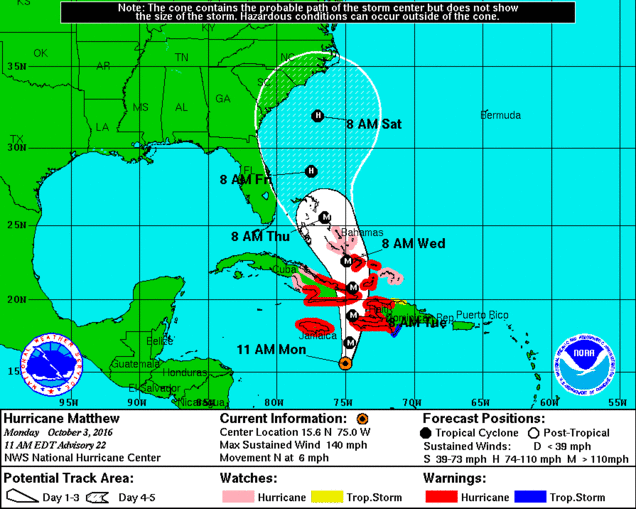 US National Hurricane Centre
Hurricane Matthews is expected to change direction and head north towards the Bahamas mid-week, before potentially hitting the east coast of the United States.
"Right now, the greatest risk is for North Carolina, but that could change," said Masters. "The only thing we're sure of as far as the US goes is that we'll see a lot of pounding waves hitting the entire east coast."
The Caribbean is now working rapidly to try to prepare for the storm, with the Haitian Civil Protection agency reportedly opening 576 temporary shelters, and the US Agency for International Development already deploying disaster response teams to Haiti and Jamaica.
At the end of last week, Hurricane Matthew reached Category 5 status in a number of hours, making it the strongest Atlantic tropical storm since Hurricane Felix in 2007 - but has since eased back down to a still-powerful Category 4.
Stay safe out there guys. It's a big one.