Artificial islands may seem a modern invention better associated with Dubai and China, but in Scotland, humans have been building them for thousands of years.
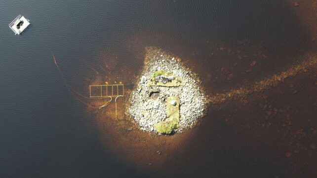
It turns out one such 'crannog' in Loch Bhorgastail on the Isle of Lewis was first constructed more than 5,000 years ago, meaning it was built by prehistoric humans during the Late Neolithic.
Using new technology, scientists have now discovered the wooden and stone foundations that established the Loch Bhorgastail crannog many millennia ago.
"Crannogs are small artificial islands that are typically thousands of years old," explains archaeologist Stephanie Blankshein, from the University of Southampton in the UK.
"Hundreds exist in the lochs of Scotland, and many remain unexplored or undiscovered."
"While crannogs were long thought to have been built, used and re-used, mainly between the Iron Age and the post-medieval period, we now know that some were first constructed much earlier during the Neolithic between 3800 and 3300 BCE."
Archaeologists did not have an easy time probing the foundations of the Loch Bhorgastail crannog to determine its vintage.
They've long known about the stone layer of the island, and the fragments of Neolithic pottery – bits of bowls and jars – found scattered in the surrounding waters.
But advances in technology recently made it possible for them to examine the site in more detail.
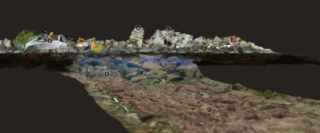
The team employed a technique called stereophotogrammetry, which helps piece together a three-dimensional model of an object, using photos taken from different positions around the object.

Most archaeologists use drones for this, since the drone's path (and therefore the camera's) can be easily mapped using global satellite navigation systems (GNSS) when it comes time to stitch together the 3D image.
But many of the important features of the crannog in Loch Bhorgastail are submerged in shallow, murky water: not ideal for the clear pictures needed for photogrammetry, or the GNSS needed to track the camera's path, since the radio signals involved do not penetrate water.
"Fine sediments, choppy conditions, floating vegetation, and distorted or reflected light all hinder shallow water imaging," says maritime archaeologist Fraser Sturt from the University of Southampton.
"Photogrammetry is very effective in deep water but runs into problems at depths of less than a meter. This problem is a well-known frustration for archaeologists."
To overcome this, a diver swam with two wide-angle, low-light cameras mounted on a single frame along a precise path underwater.
This method proved just as accurate as an aerial drone in terms of positioning, and provided a much clearer view of what was going on under the waves. You can explore the 3D model for yourself below.
Loch Bhorgastail crannog 2021 - complete model by Islands of Stone on Sketchfab
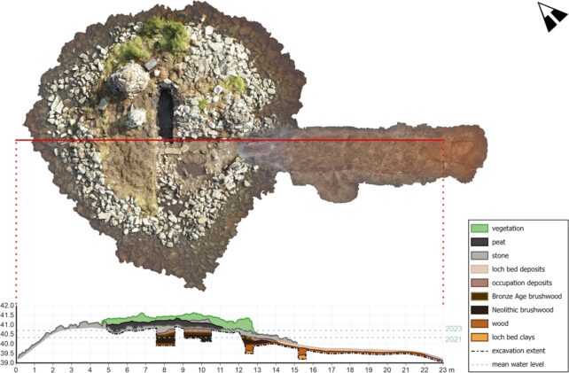
This and other models were imperative to planning more traditional methods of archaeological fieldwork at the site: Namely, excavation of the crannog's prehistoric foundations, along with radiocarbon dating the materials therein.
"As excavation advanced, it quickly became apparent that the terrestrial and underwater components formed a single continuous structure spanning both environments and could not be treated separately," Sturt, Blankshein, and the team explain in a peer-reviewed paper.
Beneath the island's stone capping, they found wooden foundations dating back thousands of years, visible in the combined photogrammetry model through a trench excavated below the water.
The prehistoric humans who built this crannog first laid down a circular wooden platform, topped with brushwood (a mat of large twigs) and spanning around 23 meters (75 feet), around 5,000 years ago.
About 2,000 years later, more brushwood was added, and the crannog was further reinforced with stone. At some point, a stone causeway was added, too, connecting the crannog to the nearby loch shore.
The study is exciting proof of a new technique for imaging underwater archaeological sites with rigor on par with those above the waterline.
It's also an astonishing reminder that humans have been engineering the landscape for millennia.
It's unclear exactly what purpose this crannog was built for, but the detritus of human life that surrounds it suggests it served people well across the ages.
The research was published in Advances in Archaeological Practice.