Beneath a fast-flowing ice stream in West Antarctica, scientists have discovered a vast aquifer brimming with seawater that's likely been locked down there for thousands of years.
This is the first time scientists have detected groundwater beneath an ice stream in Antarctica, and the discovery could reshape our understanding of how the frigid continent reacts to climate change and what kinds of mysterious organisms lurk beneath its many ice shelves.
The newfound groundwater system can be thought of as a giant sponge, made up of porous sediment and saturated with water, said Chloe D. Gustafson, lead author of a new study on the buried aquifer, formerly a geophysicist at Columbia University's Lamont-Doherty Earth Observatory and now based at UC San Diego's Scripps Institution of Oceanography.
"The 'sponge' that we observe is anywhere from half a kilometer to about two kilometers thick [0.3 to 1.2 miles], so it's pretty deep," she told Live Science.
Gustafson and her colleagues described the sizable aquifer in a report published Thursday (May 5) in the journal Science. The aquifer lies beneath the same ice stream as a subglacial lake called Lake Whillans, which sits at a shallower depth, about 2,625 feet (800 meters) under the ice.
"For me, the most surprising result is the sheer volume of water held inside the aquifer," said Winnie Chu, a glacier geophysicist at the Georgia Institute of Technology's School of Earth and Atmospheric Sciences, who was not involved in the study.
The authors estimated that the enormous aquifer holds more than 10 times the volume of water contained in the shallower system of lakes and rivers found at the base of the ice shelf. This shallow system includes Lake Whillans, which measures 20 square miles (60 square kilometers) in area and is about 7 feet (2.1 m) deep.
Related: Unimaginable diversity of life discovered beneath Antarctic ice shelf
'An MRI of the Earth'
Scientists have long speculated that huge aquifers might lie hidden beneath Antarctic ice, in part because the continent's ice streams and glaciers glide over a bed of permeable sediment that water should be able to penetrate, Chu said.
However, until now, technological limitations prevented researchers from gathering direct evidence of such deep hydrological systems, meaning systems made up of water, she explained. Instead, research focused on relatively shallow lakes and rivers found at or near the base of glaciers and ice shelves.
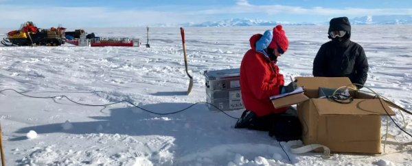
To peer beyond these shallow systems into the hidden depths below, Gustafson and her colleagues used a technique called "magnetotelluric imaging". They took measurements from the Whillans ice stream in West Antarctica, a moving belt of ice that measures about 0.5 miles (0.8 km) thick and moves about 6 feet (1.8 meters) per day in its flows towards the nearby Ross Ice Shelf.
Magnetotelluric imaging relies on electromagnetic fields generated by solar winds interacting with Earth's ionosphere – a dense layer of molecules and electrically charged particles in the upper atmosphere.
When solar winds strike the ionosphere, they excite the particles within and generate moving electromagnetic fields that penetrate Earth's surface. These moving fields then induce secondary fields in the ice, snow and sediments, and it's these secondary fields that the magnetotelluric instruments measure. The team buried these instruments in shallow pits in the snow and gathered data from roughly four dozen different locations on the ice stream.
"These secondary fields are really tightly coupled to geology and hydrology, specifically," which means that ice looks very different from sediments, salt water looks different from freshwater, and so on, Gustafson said.
"This is like taking an MRI of the Earth, and our signal just comes from the sun interacting with Earth's magnetic field," she said.
Related: Massive iceberg narrowly avoided collision with Antarctic ice shelf
Other teams of scientists had used this mega-MRI in Antarctica before, to examine Earth's crust and upper mantle; these studies started as early as the 1990s, according to a 2019 review in the journal Surveys in Geophysics.
Gustafson's team, instead, took measurements from a shallower depth, extending from the base of the stream to about 3 miles (5 km) down. There, they discovered a thick, sediment sponge with incredibly salty seawater at its deepest depths and freshwater near its shallowest part, where the sponge approached the ice stream.
This gradient suggests that the shallow, subglacial systems link up to the deep-seated aquifer, and that both likely influence the flow of ice above, Gustafson said.
"Right now, it isn't clear if the aquifer can exchange water from time to time with the subglacial hydrology or is it a one-way transfer," where water from the ice stream trickles down and then remains stored in the aquifer for some time, Chu said.
Depending on the scenario, the aquifer may be lubricating the ice stream by periodically injecting water into the subglacial system or it may be removing water from the system; both of these dynamics would affect the flow of the ice stream above, Chu added.
The exchange of water between the deep system and shallow system could also affect what types of microbial life grow beneath the ice stream and how those microorganisms survive, Gustafson said. That's because the flow of liquid water through the aquifer and interconnected lakes and rivers above drives the flow of nutrients through the ecosystem. Plus, the gradient of saltwater to freshwater shapes what kinds of microbes can survive in each environment.
Related: Microbes that feast on crushed rocks thrive in Antarctica's ice-covered lakes
Regarding the saltiest water in the depths of the aquifer, the authors hypothesized that the water likely flowed from the ocean into the groundwater system some 5,000 to 7,000 years ago, during a warm period in the mid-Holocene epoch when the West Antarctic ice sheet was in retreat.
Then, "as the ice sheet readvanced, the presence of thick ice cut off ocean access to the bed, and the remnant seawater was sealed as groundwater beneath the Whillans ice stream," Chu wrote in a commentary of the study, also published May 5 in Science.
The aquifer beneath the Whillans ice stream is the first to be detected, but the research team suspects that such hydrological systems lie beneath all the ice streams in Antarctica, and are just waiting to be discovered. These groundwater systems likely "extend hundreds of kilometers back into the ice sheet interior," Gustafson said. The next step will be to gather evidence of such systems elsewhere on the continent and compare what they found at Whillans to other regions.
In particular, how might the aquifer beneath the rapidly-thinning Thwaites glacier – otherwise known as the "Doomsday Glacier" – differ from the one under Whillans, and how do these deep systems affect the flow and melt of the ice above? Current models of ice flow don't factor in such aquifers, so that will be an interesting area of research going forward, Gustafson said.
"There is still so much we need to learn about the interconnection between groundwater hydrology and the rest of the ice sheet hydrology before we can say anything concrete about how groundwater hydrology may alter the effects of climate change on Antarctica," Chu said.
Related content:
Half of Antarctic ice shelves could collapse in a flash, thanks to warming
Sudden collapse of Antarctic ice shelf could be sign of things to come
Giant crack frees a massive iceberg in Antarctica
This article was originally published by Live Science. Read the original article here.