Earth's last major ice age locked up gargantuan amounts of water in vast glaciers. Once they melted, it was a spectacle to behold as tremendous floods gouged channels into the face of the planet.
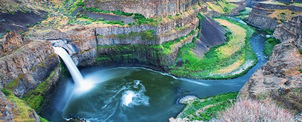
The remnants of one of the largest of these ancient deluges are still visible in eastern Washington, in an area now known as the Channeled Scablands. For a long time, geologists have been struggling to understand the dynamic properties of these floods, until a recent key insight was made.
These ancient glaciers were so large and heavy, they actually tilted Earth's crust beneath them – when weight was released due to melting, the land would have moved too, changing the course of the megaflood.
Using modeling of ancient megafloods, researchers decided to test whether glacial isostatic adjustment (GIA) – deflections in the crust as heavy chunks of ice form and melt – would affect the routing flow and erosion in two prominent Scabland tracks.
"We used relatively simple, yet plausible, numerical experiments to test whether GIA could have had a substantial impact on flood routing and erosion for two major scabland tracts, Cheney-Palouse and Telford-Crab Creek," write the authors of the study.
"To this end, we modeled GIA to reconstruct the topography of the Channeled Scabland at different times during the period of Ice Age flooding."
Up until now, reconstructions of ancient megaflood routing had investigated how other variables would affect them – things like erosion and the movement of sediment, the three-dimensional mechanics of the environment, or how ice dams break, for example.
But they would also base these reconstructions on present-day topography, approximating how past landscapes may have looked.
"People have been looking at high water marks and trying to reconstruct the size of these floods, but all of the estimates are based on looking at the present-day topography," said lead author Tamara Pico, assistant professor of Earth and planetary sciences at UC Santa Cruz.
Geologists realized that the effects melting glaciers were having on Earth's crust were also likely playing a role in the routing and behavior of these megafloods.
"GIA caused crustal deformation in the Channeled Scabland with rates up to 10 millimeters per year, orders of magnitude above regional tectonic uplift rates and, therefore, may have influenced flood routing," note the authors.
"The course of ancient, glacial outburst floods was likely influenced by glacial isostatic adjustment (GIA), and reconstructing these events informs our understanding of how floods shape landscapes on Earth and Mars," they added.
Ice sheets covered a vast area of North America during the last ice age, but they began to melt around 20,000 years ago. The Missoula megafloods are thought to have happened between 18,000 and 15,500 years ago.
Glacial Lake Missoula formed when a large chunk of the Cordilleran ice sheet dammed the Clark Fork Valley, with glacial melt water building up behind it. Eventually, a combination of factors led to the breaking of the dam, resulting in the first glacial megaflood.
However, once enough water had flown through, the ice dam reformed and the water began to build up again. It's likely that this process occurred several times over the next few thousand years.
The researchers believe the deformation of Earth's crust due to the expanding and contacting of the ice sheets would have altered the elevation of the landscape by hundreds of meters over this period.
Moving forward, the researchers want to simulate past megaflood events which incorporate the multiple factors that determine their routing. However, understanding the important role that ice age crustal deformation plays during flood routing and erosion in these ancient megafloods is a step in the right direction.
The research also points to how truly dynamic the landscape once was. Littered with steep canyons hundreds of feet deep, dry falls and massive potholes, the geological artifacts tell the tale of a land that was once subject to titanic forces.
"When you are there in person, it's crazy to think about the scale of the floods needed to carve those canyons, which are now dry," says Pico.
Pico also mentions that the oral histories of Native American tribes in the region include references to massive floods.
"Scientists were not the first people to look at this," she says. "People may even have been there to witness these floods."
The study was published in the Proceedings of the National Academy of Sciences.