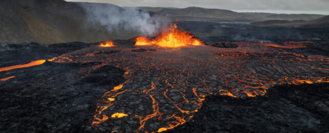
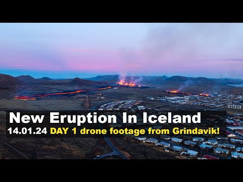
The centuries-old volcanic fissures opening up in Iceland, oozing out red-hot lava, have had residents of the nearby town of Grindavik on edge, and spectators elsewhere transfixed.
Lava flowing from one fissure engulfed several homes. The danger appears to be subsiding, with seismic activity decreasing and hazard warnings downgraded though still high.
But Grindavik is still at risk of fault movements, lava flow, and more fissures erupting without warning, as of January 19 when the Icelandic Met Office issued its last update.
New satellite imagery from NASA also shows how much heat is still leaking out of the fissures near Grindavik, a faultline that had been quiet for 800 years before this sudden spell of volcanic activity.
The map below depicts the heat emanating from the fractured land surface, detected by a thermal infrared sensor aboard NASA's Landsat 9 satellite. While the temperature scale isn't specific, it reveals the sheer size of the fissures bubbling hot with lava.
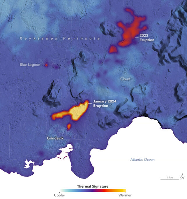
The map data was collected on 16 January 2024, two days after two fissures opened up frighteningly close to Grindavik, on January 14.
Overlaid on a digital elevation model of the area, you can see the first January 14 fissure, which grew to nearly 900 meters long as it was redirected along machine-built barriers, and the second, smaller one that breached the town's perimeter, are both blistering fountains of lava.
The lava flows from an earlier eruption in December 2023 are also still red-hot.
What the map doesn't show, however, are the below-ground intrusions of magma that flowed toward Grindavik and the flurry of earthquakes that prompted authorities to evacuate the town in January – for the second time in a matter of months. That kind of seismic data is collected on the ground, and is still being closely monitored by geologists.
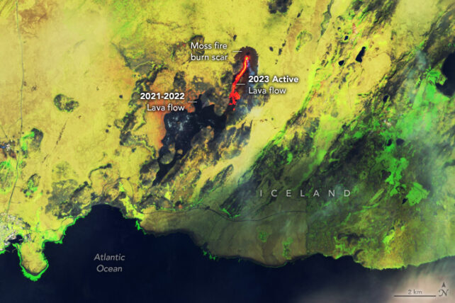
The fissure eruptions near Grindavik, in December 2023 and January 2024, are the fourth and fifth along the Reykjanes peninsula in less than three years.
An earlier image produced last year from data also collected from the Landsat 9 satellite shows lava flows that spilled from the Fagradalsfjall volcanic system northeast of Grindavik in March 2021, August 2022, and July 2023, scorching the earth black.
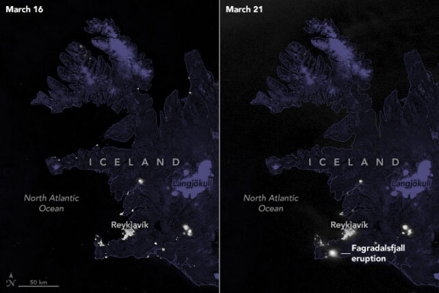
In March 2021, another of NASA's satellites, jointly operated with the National Oceanic and Atmospheric Administration (NOAA), captured the moment when Fagradalsfjall first erupted, lighting up the night.
Before this latest spate of eruptions, the Reykjanes peninsula had lain dormant for 800 years, with the last series of eruptions lasting a few decades, between roughly 1210 and 1240. Grindavik was built on top of those old, hardened lava flows, so its residents are no strangers to volcanic activity.
Iceland is one of the most volcanically active places on Earth, perched atop a mid-ocean ridge that is slowly separating and a mantle plume billowing up from below.
As Jaime Toro, a geologist at West Virginia University, recently explained, the island is sliced in two by the tectonic plate boundary between the North American and Eurasian plates, a continental faultline that bypasses Iceland's capital of Reykjavik and runs straight through the Reykjanes peninsula, where Grindavik sits close to its tip.
Hopefully, the simmering volcanic activity beneath the Reykjanes peninsula has settled for now. The Icelandic Met Office posts its updates here.