Hurricane Dorian has been unleashing an impressive lightning storm as it continues on its tragically destructive way. Looping together satellite images from the end of August, meteorologist Dakota Smith has put together a spectacular show of flashing lights within and around the storm's swirling eye.
"I created the loop mainly to visualise how incredible hurricanes are," Smith, who works at at the US National Center for Atmospheric Research, told ScienceAlert.
"The new satellite imagery we can get our hands on is incredible."
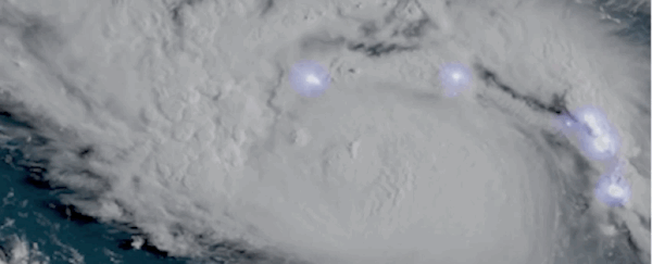
Hurricane Dorian putting on a lightning show tonight.
— Dakota Smith (@weatherdak) August 30, 2019
Spectacular imagery. pic.twitter.com/cdrs22PZqe
Not only do Smith's videos depict the storm's violent lights show, but they also indicate potentially brewing trouble. A number of flashes in Dorian's inner core, caught by satellites in the last days of August, suggested the worst was yet to come.

Lightning flashes during a tropical cyclone aren't exactly rare, but they usually strike quite infrequently and are generally confined to the periphery. To see them popping up regularly in the eyewall of Dorian is therefore an ominous indication.
"Lightning in the eyewall does normally signify deep convection," Smith explained to ScienceAlert. "This usually means the storm is maintaining or increasing in strength."
Hurricanes are the most deadly storms on Earth, and recent research indicates that lightning activity tends to increase right before one of these storms intensifies.
Several observations over the years have revealed that when a hurricane is growing rapidly, it can produce abundant lightning activity in its very centre.
Take a look at all that lightning! The Geostationary Lightning Mapper aboard NOAA's #GOESEast captured this view of all the lightning associated with #HurricaneDorian2019 in the morning hours of Aug. 30, 2019. Follow the storm's path here: https://t.co/raWlm8629m pic.twitter.com/qxOMNmzXIq
— NOAA Satellites (@NOAASatellites) August 30, 2019
Because the eye of a tropical hurricane or cyclone is warmer than the air that lies over the ocean, this creates weaker updrafts in the middle of the storm. According to NOAA, this means the inner core contains less super-cooled water, which is what provides the necessary electrical charge for a thunderstorm.
But when convection suddenly changes, creating small bursts in the centre of the storm, electrical currents can run amock.
As a result, lightning flashes are thought to be a useful tool for forecasting hurricanes. While scientists are still working out exactly what these flashes can tell us, from the little we know so far, when lightning shows up in the eye of a hurricane, it's not something to ignore.
"Generally there's not a lot of lightning in the hurricane eyewall region," explained atmospheric scientist Richard Blakeslee on the NASA website.
"So when people detect a lot of lightning in a hurricane, they perk up - they say, okay, something's happening."
Two days after these lightning storms first showed up, Dorian was upgraded to Category 5 status, hitting the Bahamas with full force. Today, the storm is currently pummelling the island nation and it's predicted to continue on to Florida and the Carolinas later this week.
After reaching a peak on Sunday, the storm is now classified as a Category 4 'major' hurricane, which means it has the power to rip roofs off houses and uproot trees with its 233 km/h winds (145 mph).
Dorian is estimated to be the second-most powerful hurricane ever recorded in the Atlantic Ocean.