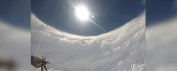
An eerily calm photo taken Sunday shows the eye of Hurricane Dorian, one of the most powerful storms ever seen in the Atlantic.
US Air Force pilots known as hurricane hunters are flying regular reconnaissance missions into Dorian, which strengthened to a Category 5 hurricane early Sunday as it tore through the northern Bahamas.
Garrett Black, a meteorologist with the US Air Force's 53rd Weather Reconnaissance Squadron, flew through the eye on Sunday, giving a glimpse inside the destructive storm.
Video from the National Hurricane Centre shows a plane making its way through the cloud.
INSIDE THE EYE OF HURRICANE DORIAN - #NOAA42 Kermit flies through Category 5 Hurricane #Dorian on 09/01/19 morning mission (credit: Ian Sears, NOAA). Forecasts and advisories at https://t.co/3phpgKMZaS, preparation tips at https://t.co/ZUC1oGAvw6 #FlyNOAA pic.twitter.com/iclEmItCtb
— NOAA Aircraft Operations Center (@NOAA_HurrHunter) September 2, 2019
The vertical stacks of thick ominous cloud seen in the photo and video are known to meteorologists as the "stadium effect" – a sign of a particularly powerful storm.
People in northern parts of the Bahamas posted videos and pictures to social media on Sunday showing violent rains, winds, and flooding clattering the Abaco Islands.
As #HurricaneDorian approached the #AbacoIslands, NOAA's #GOESEast zoomed in on the powerful storm's eye. The Cat. 5 storm's "maximum winds have increased to near 175 mph with gusts over 200 mph," according to @NHC_Atlantic. Follow the storm: https://t.co/VDEWvXtPxt pic.twitter.com/wLnZjJJYMO
— NOAA Satellites (@NOAASatellites) September 1, 2019
The National Hurricane Centre on Sunday said it recorded maximum sustained wind speeds of 185 mph as the eye made landfall on the Abaco Islands, tying Dorian for the strongest Atlantic hurricane landfall on record.
"You cannot tell the difference as to the beginning of the street versus where the ocean begins," Hubert Minnis, the prime minister of the Bahamas, said.
Hurricane Dorian is now making its way toward Florida, Georgia, and the Carolinas.
It is expected to cause life-threatening storm surge and devastating winds in the US starting as early as Tuesday.
Florida, Georgia, and South Carolina have declared states of emergency.
This article was originally published by Business Insider.
More from Business Insider: