The political separation of Britain from Europe - dubbed Brexit - might have featured heavily in the headlines in the past year, but the original cleaving of these two land masses was even more cataclysmic, and began some 450,000 years ago.
Back then, Britain was connected to the rest of the European continent via a massive land bridge that stretched from the British mainland to France. That is, until icy waterfalls began to cascade over this tenuous land link, which ultimately gave way in a torrent of catastrophic flooding, new research suggests.
"A chance series of geological events set the stage for Britain becoming an island," Earth scientist Sanjeev Gupta from Imperial College London told Nicola Davis at The Guardian.
"If it weren't for these events, in a sense the history of Britain would have been completely different."
Gupta's team analysed seafloor data collected from research vessels in the English Channel, the waters in between England and France, and specifically the seabed underneath the Dover Strait - the narrowest part of the Channel, between the port cities of Dover in England and Calais in France.
This passage between England and France is marked by a number of huge holes in the seabed, measuring several kilometres in diameter and extending into the seabed up to some 100 metres (328 feet) deep.
There are seven of these gigantic plunge pools along the seabed, running in a straight line between Dover and Calais, and it's never been entirely clear what caused them.
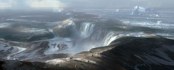
According to the team's analysis, these huge indentations are the marks caused by the deluge of a massive waterfall, with the land bridge that once extended between Britain and Europe acting like a colossal dam that held the waters of an icy lake, which we now know as the North Sea.
"Based on the evidence that we've seen, we believe the Dover Strait 450,000 years ago would have been a huge rock ridge made of chalk joining Britain to France, looking more like the frozen tundra in Siberia than the green environment we know today," says one of the team, Jenny Collier, in a press release.
"It would have been a cold world dotted with waterfalls plunging over the iconic white chalk escarpment that we see today in the White Cliffs of Dover."
This epic stretch of waterfalls would have extended for some 32 kilometres (19.9 miles) in between Britain and France, the researchers think, and would have stood as high as 100 metres (328 feet) above the valley to its south-west.
To the ridge's north-east, the area now known as the North Sea, would have formed a huge proglacial lake fed by a giant ice sheet that once spanned from Britain to Scandinavia.
This icy water was held in by the land bridge forming a natural dam, but at some point it began to spill over, scarring the valley below with its torrential impacts.

"We still don't know for sure why the proglacial lake spilt over," says Collier. "Perhaps part of the ice sheet broke off, collapsing into the lake, causing a surge that carved a path for the water to cascade off the chalk ridge.
That cascading water must have run for some time in order to create the holes in the seabed, but the waterfalls were then succeeded by a second major event.
Around 160,000 years, the team says some kind of catastrophic flood occurred – perhaps triggered by seismic activity and fed by frigid waters coming from ice sheets upstream – and which ultimately helped to breach the remnants of the land bridge.
"In terms of the catastrophic failure of the ridge, maybe an earth tremor, which is still characteristic of this region today, further weakened the ridge," says Collier.
"This may have caused the chalk ridge to collapse, releasing the megaflood that we have found evidence for in our studies.
The researchers acknowledge they'll need to conduct more studies to nail down their hypothesis and provide a more precise timeline of events. To do so, they intend to collect sediment samples from the plunge pools to find out more on the timing of the erosion.
But that's no easy undertaking, given the Dover Strait experiences huge tidal changes, and also happens to be the world's busiest shipping lane.
"It's quite hard to persuade ships' captains to do it," Gupta told Nicholas Wade at The New York Times. "I'd say we know more about Mars than the submarine geology of these continental shelves around the world."
The findings are reported in Nature Communications.