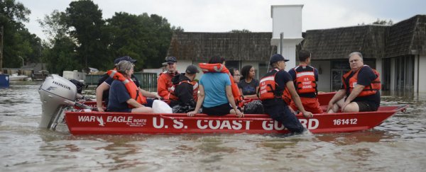
The severe flooding that submerged Louisiana last month and killed 13 people was described as the worst US natural disaster since Hurricane Sandy in 2012.
Now the US National Oceanic and Atmospheric Administration (NOAA) warns that we can expect more of the same kinds of extreme weather in the future, finding that human-caused climate change raises the risk of such torrential rains by at least 40 percent.
"We found human-caused, heat-trapping greenhouse gases can play a measurable role in events such as the August rains that resulted in such devastating floods, affecting so many people," says researcher Karin van der Wiel from the NOAA's Geophysical Fluid Dynamics Laboratory.
"While we concluded that 40 percent is the minimum increase in the chances of such rains, we found that the mostly likely impact of climate change is a near doubling of the odds of such a storm."
The researchers ran modelling based on a statistical analysis of rainfall observations to see how much more likely intense three-day downpours like Louisiana's are now compared to a century ago.
Focussing on the central US Gulf Coast – the coastline that fronts the Gulf of Mexico – the simulations took into account the levels of greenhouse gases in the atmosphere, aerosols such as soot and dust, and ozone variables.
It's worth noting that the study is still undergoing peer-review, so we need to bear that in mind when considering the researcher's calculations.
But the models so far suggest that such extreme rain events can now be expected to occur in the region about every 30 years on average, whereas in 1900, it was more like once every 50 years.
"The global climate models tell a similar story," the researchers write in Hydrology and Earth System Sciences, "with the regional probability of three-day extreme precipitation increasing due to anthropogenic climate change by a factor of more than a factor 1.4 in the most accurate analyses."
In addition to frequency, the intensity of these freak downpours is also significantly greater now. The researchers think a typical extreme rain event last century would have released about 10 percent less rainfall than a similar storm today.
In the case of Louisiana, the downpour resulted from extreme humidity combining with a stationary low pressure system.
"The moisture component is where climate change comes in — warmer air can hold more water vapour," Angela Fritz explains for The Washington Post. "As the air warms due to greenhouse gas emissions, the air gets more humid, and there's more moisture that generates more rain."
And what a level of rain that was. An estimated 26.9 trillion litres (7.1 trillion gallons) was recorded – some three times the amount of Hurricane Katrina's deluge – and in the process, more than 30,000 people had to be rescued, over 60,000 homes were damaged, and 13 lives were cut short.
In total, the damage bill is expected to be in the vicinity of US$9 billion, and the recovery will take years to complete.
If there's a silver lining in any of this, it's that we're getting better at understanding what climate change is doing to our weather patterns. Those greater insights could help fortify public efforts to combat global warming – and they might also give us an edge in weathering the more frequent storms that lie ahead.
"Researchers, communities and businesses alike see the value in these analyses," NOAA spokesperson Monica Allen told Henry Fountain at The New York Times. "They help us grapple with what has happened and strengthen our ability to stay resilient to future events."