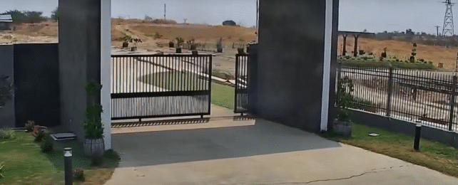
A horrifying security video has captured the moment Earth's crust cracks and slides during a devastating earthquake earlier this year. This kind of dramatic surface displacement is usually experienced in the moment or measured after the fact, but rarely – if ever – caught in action.
On 28 March 2025, a magnitude 7.7 earthquake struck Myanmar, killing more than 3,700 people and injuring thousands more. Occurring at a shallow depth of just 10 kilometers (6.2 miles) and propagating over 460 kilometers, this supershear quake ruptured the surface and displaced some areas by more than 6 meters (20 feet).
It's one thing to read those statistics, but it's another entirely to see it actually happen before your eyes. A security camera at GP Energy Myanmar's Thapyay Wa solar energy facility captured the moment, seen in a video uploaded to Facebook by Htin Aung.

As the video starts, a calm, pleasant-looking day is interrupted by shaking that gradually gets more violent. Bushes start rustling, and the gate slides open. Standard earthquake fare so far.
But around the 14-second mark, a huge crack forms and the entire ground outside slides unnervingly for a few seconds. According to Aung, the ground shifted by about 12 feet.
The effects of these quakes are very visible afterwards, but it's quite alarming to see this sort of seismological shuffle happen in real time. This may be the first instance of a ground rupture captured on video – or at least, it's an unparalleled example out of just a few.
"To my knowledge, this is the best video we have of a throughgoing surface rupture of a very large earthquake," Rick Aster, a geophysicist at Colorado State University, told Stephanie Pappas at Live Science.
The fault rupture, which stretched from Singu in the Mandalay Region to Pyu in the Bago Region, lasted just over 80 seconds, with the most intense seismic energy released about 30 seconds after it began. The rupture is believed to have moved faster than the surrounding shear waves, which makes the event a rare supershear earthquake.
"Myanmar has a long history of significant seismic activity due to its complex tectonic setting," a team led by civil engineer Khan Shahzada from Pakistan's University of Engineering and Technology writes in a paper exploring the effects of the 2025 earthquake.
The Sagaing Fault is the most active in the region, running for more than 1,400 kilometers through Myanmar and marking the boundary where two tectonic plates slide past each other. Large cities like Mandalay are located close to this fault and face a high risk of devastation.
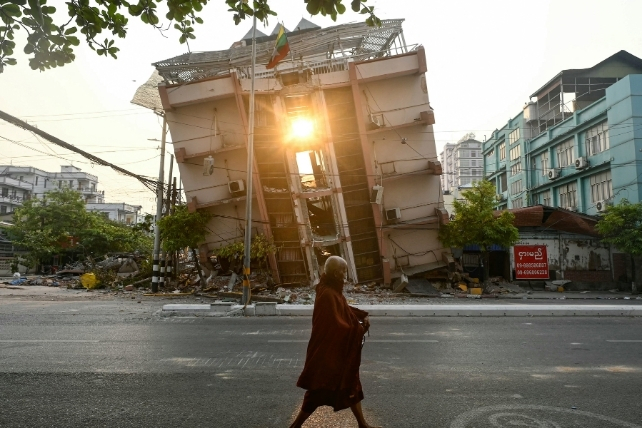
The March event has been reported as the most powerful earthquake to strike Myanmar since 1912, and the deadliest in Myanmar's history since 1930.
"The 2025 rupture uniquely highlighted cascading risks," Shahzada and his colleagues write.
"Its supershear velocity and extensive surface deformation triggered secondary disasters, from infrastructure collapse in Myanmar to high-rise failures in Bangkok's soft-soil basins."
Earthquakes are among the most catastrophic natural disasters, often taking us by surprise. Scientists are continuing to study triggers to find better ways to predict their occurrence.
The research exploring the effects of the earthquake in detail was published in The Journal of Dynamic Disasters.