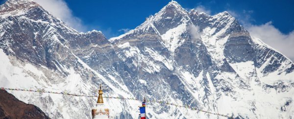
The tragic human toll of the devastating 7.8-magnitude earthquake in Nepal on 25 April has been well-documented, but one of the quake's most high-profile casualties may come as a bit of a surprise. Scientists say parts of the Himalayan mountain range may have lost as much as 1.5 metres (5 feet) in height as a result of tectonic activity stemming from the quake.
"The primary stretch that had its height dropped is a 80 to 100 km stretch of the Langtang Himal (to the northwest of the capital, Kathmandu)," Richard Briggs, a geologist with the US Geological Survey, told Navin Singh Khadka at the BBC. It's believed that the height of many other peaks within the Himalayas may also have been affected by the earthquake, but primary analysis of satellite data has focused on the areas surrounding central Nepal.
Before-and-after satellite imagery captured by the European Space Agency's Sentinel-1A radar satellite indicates changes on the ground resulting from the earthquake. Estimates suggest that an area of 120 by 100 km has been impacted by significant height changes, with geologists contending that some areas have lost as much as 1.5 metres in height.
In addition to subsidence - a downwards shift in the surface caused by the earthquake in some parts of the country - other areas have risen, with Kathmandu said to have been raised by about 1 metre as a result of the earthquake. "The negative value we have received from the acquisitions of the before and after earthquake images means that some areas (Kathmandu and its surroundings) are now closer to the satellite, and that means they have seen an uplift," Christian Minet, a geologist with the German Aerospace Centre, told the BBC.
Tim Wright, professor of satellite geodesy at the University of Leeds in the UK, explained the contrasting rises and falls experienced by Nepal:
"The fault underneath Kathmandu has slipped and it's moved the overriding part of the crust to the south towards the southern end of the part that squashes the crust; and to the northern end it stretches it. From where it is squashed, which is more or less underneath Kathmandu, we get uplift. And where it stretches, which is in the high mountains to the north of Kathmandu in this case, we get subsidence."
And as for Mount Everest, the world's highest peak? Scientists say it also lost height in the earthquake, but compared to the mountains in the Langtang Himal region, Everest, which lies to the east of Kathmandu, got off lightly. It's believed to only be about an inch (2.54 cm) shorter than prior to the quake, which still gives it more than 200 metres on its nearest rival, K2).
However, none of the above height drops are expected to last long, with ongoing tectonic activity in the Himalayan region ordinarily leading to increases of about 1 cm annually. "This is only one earthquake, and the overall tectonics give you uplift of the mountains," Wright told Becky Oskin at Live Science.