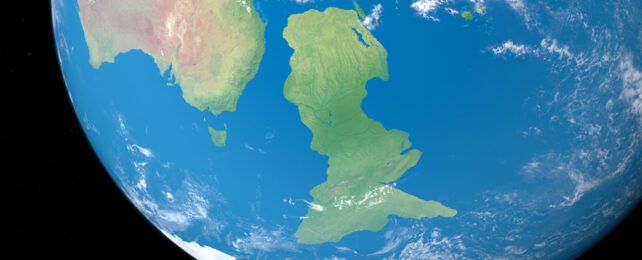
When the ancient supercontinent Gondwana was torn asunder 83 million years ago, a huge chunk of it sank beneath the waves as it drifted away.
According to some geologists, this submerged chunk – called Zealandia – would be considered Earth's 8th continent, if it weren't for a thick layer of ocean water obscuring our view.
Instead, all that now peeks above the ocean's surface is New Zealand and surrounding islands, so Zealandia itself has long remained enigmatic. About 94 percent of the 4.9 million km2 continent is submerged, hiding details of the northern part of the land mass.
Using geochemical and isotope data from newly dredged samples of rocks as well as seismic readings, GNS Science geologist Andy Tulloch and colleagues created a refined map of that region to investigate how the continent came to be.
Samples of rocks, some as old as the dinosaurs, were taken from exploration drill sites and a number of South Zealandia's exposed peaks, such as Chatham and Antipodes islands.
An analysis of their chemical makeup, along with other geological clues, revealed similarities in patterns with geology in West Antarctica, suggesting a subduction of Zealandia's edge up to a quarter of a billion years ago, across what's now the Campbell Plateau off New Zealand's west coast.
Subduction is when two edges of Earth's crust push against one another forcing one edge down into Earth's mantle. But contrary to previous suggestions, magnetic anomalies found in the same region are not related to this event.
This removes "the original argument for a strike‐slip "Campbell Fault," Tulloch and team explain in their paper. "Zealandia and Antarctica are both substantially internally deformed."
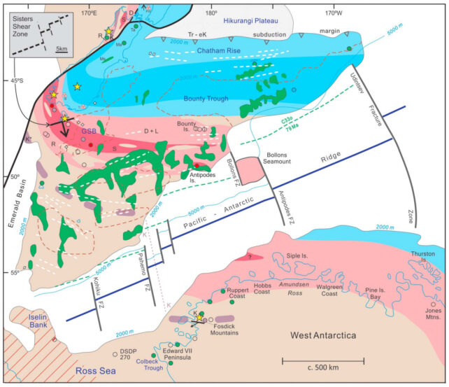
Instead, they propose, the Campbell Magnetic Anomaly System arose from extensive stretching between different parts of Gondwana that eventually snapped apart to create Zealandia's surrounding sea floors.
First the combined areas of Zealandia/West Antarctica and Antarctica/Australia cracked, allowing the Tasman sea to rush in about 83 million years ago.
Next, during the Late Cretaceous around 79 million years ago, Zealandia and West Antarctica ripped away creating the Pacific ocean.
How Zealandia's crust managed to stretch so thin before breaking away, has long puzzled geologists. Similar thinness is also apparent in West Antarctica.
Tulloch and colleagues found evidence that the stretching direction varied by up to 65 degrees between 100 to 80 million years ago. They think this may have allowed the extensive thinning of the continental crust.
Together these findings create a solid foundation for a more detailed analysis for this strange stretching of the earth.
This research was published in Tectonics.