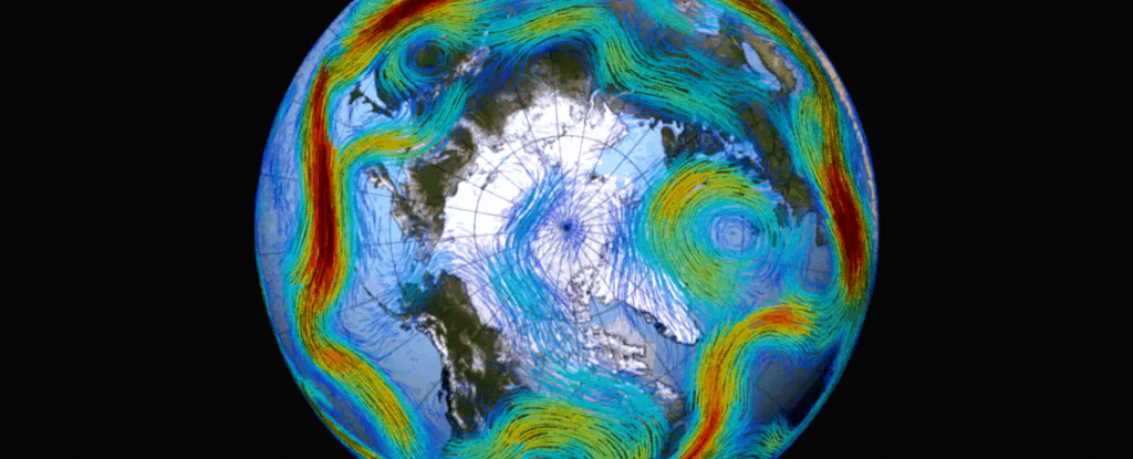
A major current of circulating air called the Arctic polar vortex has completely reversed course and is now spinning 'backwards'. With winds now blowing easterly, scientists are trying to predict what effect this might have on weather systems in the coming months.
Before you start envisioning the sudden collapse of our planet's weather systems, these reversals aren't all that unusual. While the strength of the reversed winds has attracted attention, this is not the first reversal this year.
During the summer months in the Northern Hemisphere, the vortex's circulating winds slow down and start spinning easterly (clockwise around the Arctic) too.
However, reversals from westerly to easterly during the winter months can have significant impacts, and few are as dramatic as the one we've seen in March 2024. It's in the top six strongest reversals since 1979, climate scientist Amy Butler from the National Oceanic and Atmospheric Administration (NOAA), told Spaceweather.com.
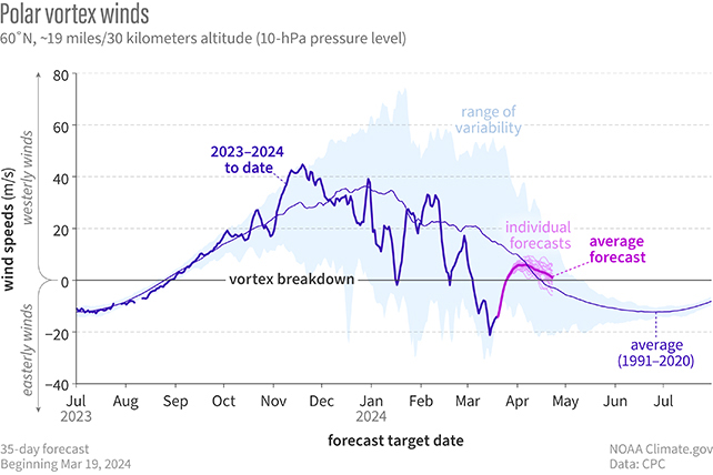
As described by NOAA climate scientist Rebecca Lindsey, this winter's stratospheric events have been anything but typical, providing "plenty of drama" to keep researchers busy until air returns to a westerly circulation in the following weeks.
The polar vortex sits in the stratosphere, which starts at around 6–20 kilometers (4–12 miles) above the planet's surface and reaches roughly 50 kilometers (around 31 miles) above. While most of the weather we experience is a feature of the troposphere below it, extreme stratospheric winds of up to 250 km/hr keep a pocket of cold air trapped over the North Pole.
Sometimes though, atmospheric waves called Rossby waves push up and weaken the polar vortex, causing some of that cold air to spill out. This is known as a Sudden Stratospheric Warming event, and it's what's happened here – it can lead to cold snaps on the ground, but not always.

It's still early days in terms of analyzing the consequences of this latest polar vortex reversal, but scientists have already seen a spike in ozone levels above the Arctic. It happens because a weaker polar vortex causes more ozone to flow to the poles and stay there, and it's the biggest Arctic ozone spike on record for March.
Ozone levels should return to normal as the polar vortex swings back into its usual counter-clockwise spin, and – so far at least – it hasn't come with any major weather swings attached. It appears that one of the most significant polar vortex reversals in history hasn't had much impact in terms of weather.
There's a longer-term view here though: as the planet gets hotter, it's not clear how the polar vortex might begin to change.
Everything from El Niño circulation patterns to sea ice coverage plays a part, and experts will be keeping a close eye on the polar vortex – and any major reversals – in the years to come.