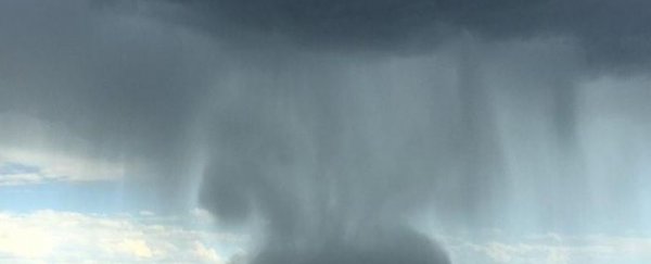
The above footage shows what looks like a "ball" of rain dropping from a thunderstorm over central Queensland, Australia, last Sunday. The footage was captured by Peter Thompson, who was working on a property around 80 km north-east of Roma at the time. The entire thing lasted just five minutes, but dumped a whole lot of rain in that short time.
This rare type of storm is known as a "microburst", or downburst of cloudburst, and it occurs when rising hot dry air mixes with rain drops in the atmosphere, casing them to evaporate and therefore lowers the temperature rapidly, as Peter Hannam explains over at The Sydney Morning Herald.
The cooled air then quickly starts to sink, gathering speed and pulling the rain with it into a forceful downfall over a small region.
"I reckon from when I first started seeing that ball form to when it hit the ground was about two minutes," Thomspon told ABC News. "The drop itself was really quite quickly. It looked like the bottom of the cloud falling."
And while it's beautiful to look at, the results can be devastating for anything caught below it, with strong winds also accompanying this type of event.
"A downburst is a concentrated downdraft, typically lasting five to 15 minutes, and is of unusually high speed such that it can cause damage on, or near, the ground," the Australian Bureau of Meteorology website explains.
The conditions in the region were unfortunately perfect for such a storm to occur last week, with temperatures during the day hovering at around 39 degrees Celsius in the shade - that's 102.2 Farenheit.
Sources: The Sydney Morning Herald, ABC News