Dust from the Sahara desert will cloud the skies of the US southeast this week in an annual weather event that doesn't always reach the American continent.
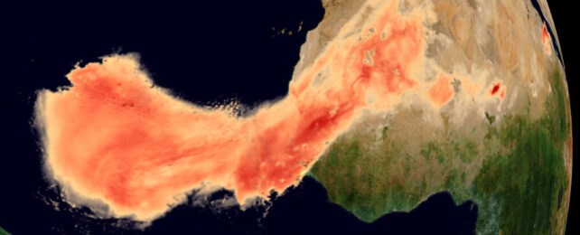
The dust clouds form as a result of an atmospheric phenomenon known as the Saharan Air Layer. As the name suggests, they've made a long journey across the Atlantic Ocean from their North African birthplace in the Sahara, the world's largest hot desert.
The Saharan Air Layer forms when massive quantities of desert dust are stirred up by tropical atmospheric waves along the desert's southern edge, ramping up around early June. Growing up to 4 kilometers (2.5 miles) thick, these dust plumes are blown across the Atlantic Ocean where they are further lifted by the denser, more humid ocean air.
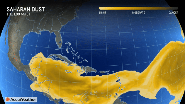
The dust follows this westward course every year. Sometimes it can even veer north, arriving in Europe. While the dust affects air quality, it can suppress hurricanes from forming in this usually tumultuous system. This may be good news, given NOAA is forecasting a hurricane-heavy season.
Caribbean islands including Jamaica, Puerto Rico, Barbados, and Trinidad and Tobago have already been cloaked in the dust; a prelude of what is expected to soon hit US states including Florida, Louisiana, Alabama, and Mississippi.
The dust is expected to reach the US on Wednesday, becoming thickest on Thursday and potentially affecting visibility before hitting some lighter winds that will allow it to dissipate. On the bright side, the clouds just might generate some stunning sunrises and sunsets along the way. It may also create warmer temperatures, particularly at night.
People with asthma, allergies, and other respiratory conditions are warned to stay inside or use face masks if outdoors.