For something as chaotic as the wind, meteorologists tend to have a pretty good grip on the kinds of circulating air patterns we might expect to see whipping up storms around the globe.
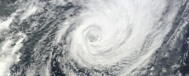
One, it seems, has until now slipped under the radar. In an effort to better understand contrasts in ocean temperature in the Indian Ocean, scientists have uncovered a new kind of tropical cyclone that occurs several times a year off the coast of Sumatra.
The unique, short-lived storms occur on a cyclical basis in the southeastern Indian Ocean. They tend to start swirling in winter and spring (in the Southern Hemisphere), when westerly equatorial winds meet north-westerly winds.
Researchers are fairly familiar with the sloshing about of large volumes of air close to the westerly equatorial winds through the summer months, specifically known as the Boreal Summer Intra-Seasonal Oscillation.
But the periodicity of these oscillations didn't quite match the storms' patterns, inviting scientists to dig further.
According to daily atmospheric data, only three significant cooling events have occurred off the coast of Sumatra since 1988, and these anomalies seem to follow a lack of cyclone activity.
The outcomes are actually quite similar to the cooling force of El Niño–Southern Oscillation (ENSO), researchers say, which occurs in the eastern equatorial Pacific.
In the equatorial Indian Ocean, the difference in sea surface temperatures in the tropical western and eastern zones is known as the Indian Ocean Dipole (IOD), and it seems to be closely tied to cyclone activity near Sumatra.
During the formation of a water-warming cyclone in the South-East Tropical Indian Ocean (SETIO), northwesterly winds intensify, while westerly equatorial winds weaken.
The whole event takes place over the course of about 10 days, and during each IOD season (July to September) season, about 5 SETIO storms occur on average – a cumulative duration of around 50 days. During some seasons, however, just one cyclone can occur.
"Dramatic changes happen in some years when SETIO cyclones fail to develop, and ambient winds trigger the appearance of cold seawater in a vast area strongly disturbing both winds and rainfall patterns over the Indian Ocean," says oceanographer Jochen Kaempf from Flinders University.
The westerly winds that flow around Sumatra have been noticed by scientists before, but it's never been understood where they came from.
"This frequent occurrence of SETIO cyclones explains their control on average equatorial zonal winds in the eastern Indian Ocean, which are almost absent otherwise," the authors write.
In fact, cyclones around the globe make up most of the wind force that flows around the equator.
During a SETIO cyclone, cold water upwellings in the southeastern Indian Ocean are suppressed by north-westerly winds – similar to how winds off the coast of Peru control La Niña upwellings.
"Hence, wind-disturbances strongly modulate the intensity of coastal upwelling and associated [sea surface temperature] anomalies in both oceans," the authors write.
"However, the intensity of equatorial upwelling is markedly different. In the Pacific Ocean, easterly trade winds induce continuous equatorial upwelling which is enhanced near the Peruvian coast. Due to the effect of SETIO cyclones, equatorial winds in the eastern Indian Ocean tend to be generally westerly and hence operate to suppress equatorial upwelling."
Given the uncertainty of Earth's future, researchers say that a better understanding of SETIO cyclones is of the utmost importance.
These storms influence the Indian Ocean Dipole, which, in turn, strongly impacts climate and rainfall in surrounding nations, including Australia.
A better understanding of atmospheric and oceanic currents in this part of the world will help improve local climate models, allowing experts to better predict where rapid global warming is headed and how we can best prepare for future disaster.
The study was published in the Journal of Southern Hemisphere Earth Systems Science.