It's not often you get the chance to peer inside a hurricane, but that's exactly what dramatic new footage from the National Oceanic and Atmospheric Administration (NOAA) gives us the opportunity to do – all you need is access to YouTube.
The video was shot inside Hurricane Sam on 30 September 2021, by a plucky sailing drone known as Saildrone Explorer SD 1045. The uncrewed surface vehicle (USV) had to battle with 120 mph (193 kph) winds and 50-foot (15-meter) high waves, according to the NOAA.
As long as you're somewhere warm, dry and safe, feel free to click on the video footage below and see for yourself: the category 4 hurricane is not something you want to be stuck inside when you're out on the ocean.

The SD 1045 is on a mission to collect real-time data that can then be used to improve hurricane prediction models. It's fitted with a special 'hurricane wing' that means it can operate and keep recording in the stormiest of conditions.
"Saildrone is going where no research vessel has ever ventured, sailing right into the eye of the hurricane, gathering data that will transform our understanding of these powerful storms," says Saildrone founder and CEO Richard Jenkins.
"After conquering the Arctic and Southern Ocean, hurricanes were the last frontier for Saildrone survivability. We are proud to have engineered a vehicle capable of operating in the most extreme weather conditions on Earth."
Measuring 7 meters or 23 feet long, the Saildrone Explorer SD 1045 is packed with meteorological and oceanographic sensors for gathering data, as well as microphones and cameras. Powered by sunlight and the wind, it uses machine learning artificial intelligence to analyze various data as it comes in.
The drone is operated by a human pilot over a satellite link, and can survive more than a year at sea. There are currently five of these autonomous devices out in the Atlantic, and the fleet as a whole has logged more than 13,000 days on the waves, covering more than 500,000 nautical miles.

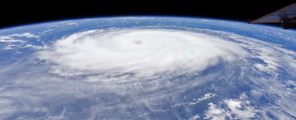
As for Hurricane Sam, it was the longest-lasting and most intense hurricane of the 2021 season in the Atlantic Ocean, though it thankfully avoided hitting land and at the time of writing has been downgraded to a category 2 storm.
In the future, this same technology could be used to track the progress of hurricanes as they develop, and ultimately to save lives by providing advance warning of what these storm systems might be doing next.
"Using data collected by saildrones, we expect to improve forecast models that predict rapid intensification of hurricanes," says oceanographer Greg Foltz from the NOAA. "Rapid intensification, when hurricane winds strengthen in a matter of hours, is a serious threat to coastal communities.
"New data from saildrones and other uncrewed systems that NOAA is using will help us better predict the forces that drive hurricanes and be able to warn communities earlier."