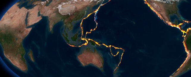
Details of a 120-million-year-old tectonic plate once a quarter the size of the Pacific have been revealed long after the section of crust was largely subsumed into Earth's innards.
Suzanna van de Lagemaat, a graduate geologist at Utrecht University in the Netherlands, and her supervisor, Douwe van Hinsbergen, deduced the plate's existence by piecing together geological data preserved in crumpled mountain ranges and oceanic fragments thrust atop continental plates throughout the Asia-Pacific region.
"We thought we were dealing with relicts of a lost plate that we already knew about," explains van de Lagemaat, who found tell-tale signs of the ancient plate in rock formations she studied in northern Borneo.
"But our magnetic lab research on those rocks indicated that our finds were originally from much farther north, and had to be remnants of a different, previously unknown plate."
Now named the Pontus plate, this chunk of Earth's crust spanned one-quarter of the present-day Pacific Ocean, the researchers estimate, based on their new reconstructions going back 160 million years.
At that time, a vast ocean existed between Eurasia and Australia, which had been tethered to Antarctica as part of the supercontinent Pangaea.
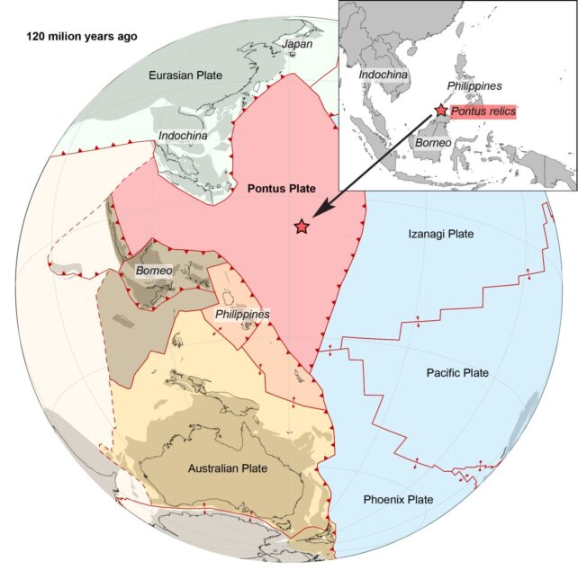
As Pangaea broke apart, the proposed Pontus plate underlying that ancient ocean was swallowed up over millions of years by insurgent plates carrying Borneo and the Philippines into their present-day positions.
Van de Lagemaat's investigations focused on the so-called Junction Region, one of the most complicated plate tectonic regions on Earth. It runs from Japan, through Borneo, the Philippines, New Guinea, and down to New Zealand.
She compiled published data and data from her own field studies in Borneo to reconstruct tectonic plate movement from the time of the dinosaurs through to the present day.
Unlike previous reconstructions of the Junction Region, van de Lagemaat and van Hinsbergen opted against using paleogeomagnetic data, the ancient record of Earth's swiveling magnetic field preserved in rock, to orient the Philippines Sea plate. Such data is sparse in this fiery region, so it may reflect deformations in the Philippines Sea plate rather than its overall movement.
Instead, the researchers considered the entire western Pacific region and its predecessor, the Panthalassa superocean which surrounded the Pangea supercontinent.
They worked backward from the current geological arrangement of tectonic plates in the Junction Region to reconstruct plate movements as far back as the Jurassic period, assuming the simplest plate tectonic scenario that fit with geological observations.
"We assumed [the] simplest plate model with the least amount of plate boundaries necessary to explain the present-day geology," the pair explains in their published paper.
If accurate, it's a satisfying result for van Hinsbergen and his colleagues, who predicted the Pontus plate's existence 11 years ago based on anomalies in seismic data.
That data pointed to fragments of an old plate that had sunk deep into Earth's mantle, disrupting the path of earthquakes that passed through.
Relics of the hypothetical Pontus plate had also been found on Palawan, an island in the Western Philippines, and in the South China Sea, which made sense once connected to the Borneo formation van de Lagemaat studied.
"It was only after Suzanna had systematically reconstructed half of the 'Ring of Fire' mountain belts from Japan, through New Guinea, to New Zealand that the proposed Pontus plate revealed itself, and it included the rocks we studied on Borneo," van Hinsbergen says.
The study has been published in Gondwana Research.