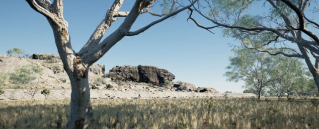
Archaeologists have mapped a hidden landscape where Australia's first people made inroads more than 60,000 years ago.
This now-inland region was once a coastal mangrove swamp and, before that, a semi-arid savannah plain hundreds of kilometers from the seashore.
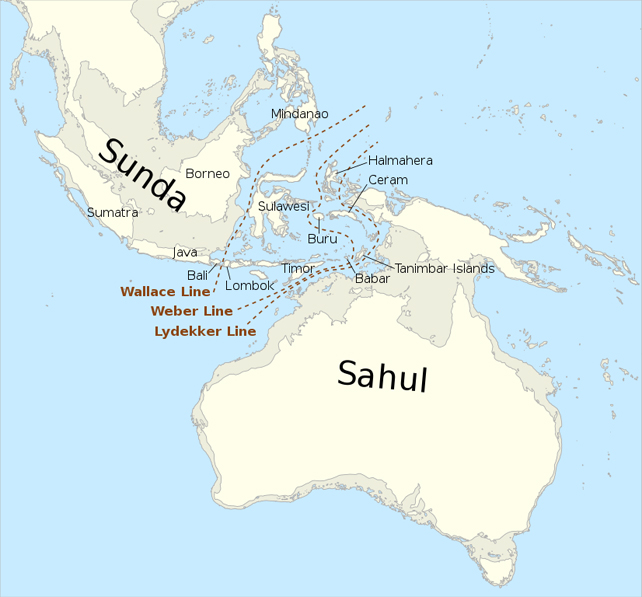
During the late Pleistocene epoch, sea levels were so low that Australia was connected to its northern neighbors, New Guinea and Indonesia, in a supercontinent known as Sahul.
But then, at the end of the last ice age, around 10,000 years ago, vast swathes of land were flooded as ice sheets melted.
We know that Australia's first peoples occupied these parts of northern Australia for at least 65,000 years based on thousands of stone tools and remnants of food scraps unearthed at the Madjedbebe rock shelter in the 2010s.
Their presence indicates a remarkable journey of skilled mariners traversing seas and land bridges to inhabit the driest continent on Earth.
But try as they might, archeologists haven't found another site as ancient as Madjedbebe yet.
It's not because such sites don't exist, but it could be because they've been looking in the wrong places, the present-day landscape obscuring possible sites tucked out of sight or submerged underwater.
To help with the search, researchers working with the local Njanjma Rangers, the traditional custodians of the Greater Red Lily Lagoon Area in West Arnhem Land, reconstructed an ancient landscape buried beneath today's seasonal floodplain.
Their efforts could redirect the search for these ancient sites occupied by Australia's first peoples by mapping the long-forgotten landscape that greeted those people when they arrived.
"We want people to see and want people to know what's been happening many thousand years ago in the past," says traditional owner and co-author Alfred Nayinggull of their work.
The team used geophysical measurements to digitally 'peel back' layers of soil and expose a string of sandstone cliffs that "for the majority of human occupation were actually exposed and probably habited by people," lead researcher, Flinders University archeologist Jarrad Kowlessar told the Australian Broadcasting Corporation.
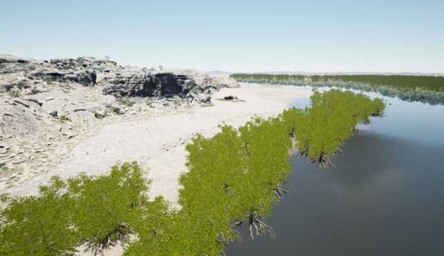
This technique is electrical resistivity tomography, and it involves passing an electrical current through the ground to measure sediments and rocks below. Comparing those results with aerial mapping, the team came to appreciate just how much the landscape has changed.
A deep valley and river system is now buried under more than 15 meters (49 feet) of sediments deposited by extensive mangroves. The researchers say it could contain sites where Australia's first people left behind rock art or stone tools. However, it remains to be seen if those artifacts have been preserved.
Researchers not involved in the work say Red Lily Lagoon's acidic soils would have likely eroded any rock art that once adorned the sandstone cliffs, but they are encouraged to look for other artifacts in the area, which is a key region for understanding the peopling of Australia.
Even before any more sites are found, visualizing these landscapes and understanding the rapid environmental change Australia's Indigenous peoples witnessed at Red Lilly Lagoon will guide interpretations of existing rock art sites that depict fish, crocodiles, and marine life.
"This [research] reveals a complex Pleistocene landscape, which offers the potential to locate additional archaeological sites and so reveal more about the lifeways of the earliest Australians," Kowlessar and colleagues write in their published paper.

It's certainly exciting times. With every passing year, it seems we are coming to understand more about Australia's deep past through research that enriches the oral histories of the country's Indigenous peoples.
In 2020, another team from Flinders University reported they had located the first submerged Aboriginal archaeological sites found on the seabed, in waters off the coast of Western Australia.
They used a similar approach to the team at Red Lily Lagoon: mapping the underwater landscape first to narrow down prospective areas before diving in to search for artifacts.
But protecting these areas steeped in history has become an urgent issue. Rock art sites on Western Australia's Burrup Peninsula are being removed and damaged by the expansion of heavy industry.
Once these sites are destroyed, our chance to see the land through the hands and eyes of ancient peoples is lost, save for the stories their descendants share.
"We need to know where those other places in Australia are, and that it was different before," says traditional owner Alfred Nayinggull. "I need to know, and the rest of the world would see, what was in the past."
The study was published in PLOS One.