For East Island, a remote stretch of sand in the Hawaiian archipelago, it was only a matter of time. And that time just came.
Satellite images released this week reveal that the entirety of East Island was basically wiped out by powerful storm surges in the wake of Hurricane Walaka, one of the most intense Pacific hurricanes on record, which tore through the region earlier in the month.
Before-and-after pictures provided by the US Fish and Wildlife Service (FWS) tell a terrifying story of what the future could hold for similarly tiny and low-lying sandy islets in the face of climate change – with rising seas and hotter weather inviting ever more devastating, island-crushing storms.
"I had a holy shit moment, thinking 'Oh my God, it's gone,'" climate scientist Chip Fletcher from the University of Hawaii told Honolulu Civil Beat.
"It's one more chink in the wall of the network of ecosystem diversity on this planet that is being dismantled."
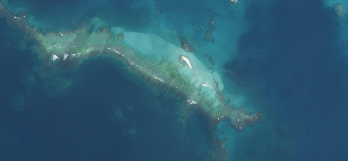 East Island after Hurricane Walaka (FWS)
That ecosystem chink is because East Island – along with the nearby (and also hurricane-damaged) Tern Island – was an important pupping ground for endangered monk seals and nesting ground for threatened green sea turtles.
This vital habitat, which now exists only under the waves, can no longer provide safe, dry territory for those animals, or for seabirds. While researchers have yet to assess the scale of the threat to local wildlife, the outlook is grave.
"Species are resilient up to a point," conservation biologist Charles Littnan from the National Oceanic and Atmospheric Administration (NOAA) told Honolulu Civil Beat.
"But there could be a point in the future where that resilience isn't enough anymore."
While East Island was only ever a tiny land mass – about 1 kilometre (approximately 0.6 miles) long and 120 metres (almost 400 ft) wide – it was the second-largest island in the French Frigate Shoals, which is the largest atoll in the Northwestern Hawaiian Islands and part of the Papahānaumokuākea Marine National Monument.
Papahānaumokuākea was listed as a protected area in 2006 – the third largest such area in the world, in fact – but Walaka's unstoppable force lays bare the limit of such designations in a world facing unthinkable climate scenarios.
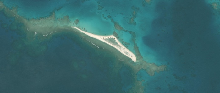 East Island as it was in May (FWS)
"This is not surprising when you consider the bad luck of a hurricane going into that vicinity and sea level rise already sort of deemed the stressor in the background for these ecosystems," Fletcher told HuffPost.
"The probability of occurrences like this goes up with climate change."
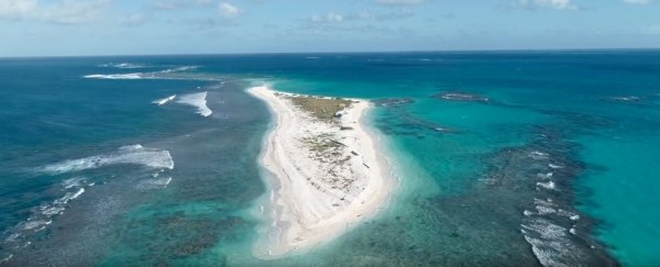
Fletcher, who suspected East Island had decades left before it was swallowed by rising seas, was conducting research there as recently as July, where he helped capture this arresting drone flyover of the island:

It's a video worth taking a look at: the last up-close glimpse the world will probably ever get of this Hawaiian wildlife haven.
Papahānaumokuākea managers are working with FWS and NOAA scientists to better understand the implications for local species and habitat in light of these developments, but the bigger questions remain unanswered.
Where else could something like this happen? What can we do to prevent it? How long do we have?
Researchers say we're only at the "beginning stages of what does this mean", but others are already predicting this vanishing island won't be an isolated incident.
"We're going to see a lot of these stories in the years ahead," environmentalist and writer Bill McKibben tweeted on seeing the news, "and every one will be so sad."