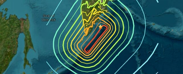
The earthquake near the east coast of the Kamchatka peninsula in Russia on 30 July 2025 generated tsunami waves that have reached Hawaii and coastal areas of the US mainland.
The earthquake's magnitude of 8.8 is significant, potentially making it one of the largest quakes ever recorded.
Countries around much of the Pacific, including in east Asia, North and South America, issued alerts and in some cases evacuation orders in anticipation of potentially devastating waves.
Waves of up to four metres hit coastal towns in Kamchatka near where the earthquake struck, apparently causing severe damage in some areas.
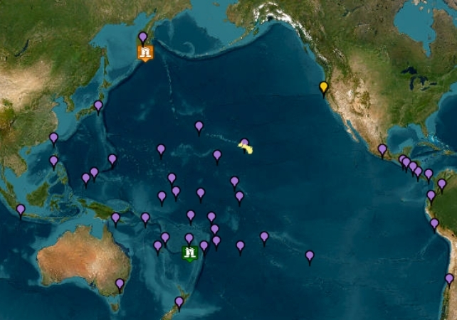
But in other places waves have been smaller than expected, including in Japan, which is much closer to Kamchatka than most of the Pacific rim. Many warnings have now been downgraded or lifted with relatively little damage.
It seems that for the size of the earthquake, the tsunami has been rather smaller than might have been the case. To understand why, we can look to geology.
Related: Giant Earthquake Off Russian Coast Triggers Mass Evacuations as Far as Hawaii
The earthquake was associated with the Pacific tectonic plate, one of several major pieces of the Earth's crust. This pushes north-west against the part of the North American plate that extends west into Russia, and is forced downwards beneath the Kamchatka peninsula in a process called subduction.
The United States Geological Survey (USGS) says the average rate of convergence – a measure of plate movement – is around 80 mm per year. This is one of the highest rates of relative movement at a plate boundary.
But this movement tends to take place as an occasional sudden movement of several metres. In any earthquake of this type and size, the displacement may occur over a contact area between the two tectonic plates of slightly less than 400 km by 150 km, according to the USGS.
The Earth's crust is made of rock that is very hard and brittle at the small scale and near the surface. But over very large areas and depths, it can deform with slightly elastic behaviour. As the subducting slab – the Pacific plate – pushes forward and descends, the depth of the ocean floor may suddenly change.
Nearer to the coastline, the crust of the overlying plate may be pushed upward as the other pushed underneath, or – as was the case off Sumatra in 2004 – the outer edge of the overlying plate may be dragged down somewhat before springing back a few metres.
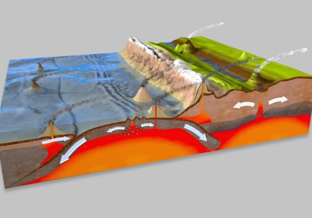
It is these near-instantaneous movements of the seabed that generate tsunami waves by displacing huge volumes of ocean water. For example, if the seabed rose just one metre across an area of 200 by 100 km where the water is 1km deep, then the volume of water displaced would fill Wembley stadium to the roof 17.5 million times.
A one-metre rise like this will then propagate away from the area of the uplift in all directions, interacting with normal wind-generated ocean waves, tides and the shape of the sea floor to produce a series of tsunami waves. In the open ocean, the tsunami wave would not be noticed by boats and ships, which is why a cruise ship in Hawaii was quickly moved out to sea.
Waves sculpted by the seabed
The tsunami waves travel across the deep ocean at up to 440 miles per hour, so they may be expected to reach any Pacific Ocean coastline within 24 hours. However, some of their energy will dissipate as they cross the ocean, so they will usually be less hazardous at the furthest coastlines away from the earthquake.
The hazard arises from how the waves are modified as the seabed rises towards a shoreline. They will slow and, as a result, grow in height, creating a surge of water towards and then beyond the normal coastline.
The Kamchatka earthquake was slightly deeper in the Earth's crust (20.7km) than the Sumatran earthquake of 2004 and the Japanese earthquake of 2011. This will have resulted in somewhat less vertical displacement of the seabed, with the movement of that seabed being slightly less instantaneous.
This is why we've seen tsunami warnings lifted some time before any tsunami waves would have arrived there. ![]()
Alan Dykes, Associate Professor in Engineering Geology, Kingston University
This article is republished from The Conversation under a Creative Commons license. Read the original article.