Hurricane season officially peaks today: September 10.
It has been a quieter-than-average hurricane season so far, but things are picking up in a big way: three hurricanes are churning in the Atlantic, with Hurricane Florence rapidly approaching the US East Coast.
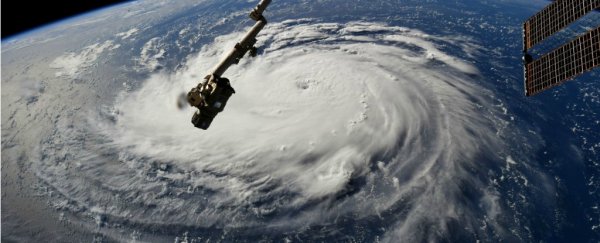
Hurricane Florence, a Category 4 storm with 140 miles per hour (225 kilometres per hour) winds, is expected to make landfall somewhere between North Carolina, South Carolina, and the Mid-Atlantic states on Thursday evening or Friday morning, according to the National Hurricane Center (NHC).
The Atlantic hurricane season officially begins on June 1, and this year was forecasted to have a slightly above-average number of storms.
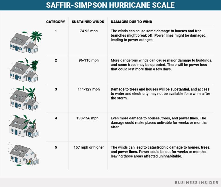
An average hurricane season includes at least 12 named storms – which may be less powerful than full-fledged hurricanes – and six hurricanes, with three of those being major storms. (To qualify as a major storm, a hurricane must be category 3 or higher on the Saffir-Simpson scale, with wind speeds in excess of 111 miles per hour (179 kilometres per hour).
Initial predictions didn't quite pan out this year – so far, we've had nine named storms and five hurricanes. Only Florence has qualified as a major hurricane.
By July, after a relatively quiescent period for Atlantic hurricanes, experts predicted that the season would end up with an average or slightly less than average number of hurricanes.
But the season is just now peaking, and Hurricanes Florence, Isaac, and Helene are a stark reminder that we are not out of the woods yet.
Beyond the damage from wind and high surf, Hurricane Florence is predicted to slow over the Carolinas where it may dump up to 30 inches (76 centimetres) of rain over much of North and South Carolina.
Hurricane Isaac, churning in the mid-Atlantic Ocean with wind speeds of around 75 miles per hour (120 kilometres per hour), is following closely behind Florence. Behind Isaac, Hurricane Helene is gaining strength, with wind speeds of over 105 miles per hour (170 kilometres per hour) as of Monday afternoon.
 (Ana Pelisson/Business Insider)
Hurricanes need warm ocean water to form, so hurricane season comes when the Atlantic Ocean is at its warmest.
Storms generally form over the equator, where the water temperature is especially high, then move north and west, pushed along by currents in the tropical Atlantic.
Sluggish or stalled hurricanes – like Hurricane Harvey, which flooded swaths of Houston, Texas and the Gulf Coast last year – can become even more dangerous as they stick around, pouring rain.
These types of slow-moving hurricanes are becoming more frequent. Recent research from the National Oceanic and Atmospheric Administration found that storms slowed by an average of 10 percent over land between 1949 and 2016.
Hurricanes are also getting windier, wetter, and more powerful because of climate change. As the atmosphere warms, the air can hold more moisture, which allows storms to become stronger and produce more devastating rainfall.
More powerful hurricanes also bring higher-than-average storm surges, which can destroy coastal property.
Rising global temperatures also make ocean water warmer, which can push hurricanes further up the coast.
"People that have typically not been exposed to them will now be exposed to them, because the storms are going to move deeper inland and affect more people," climate scientist Cindy Bruyere, who studies storms at the University Corporation for Atmospheric Research, previously told Business Insider.
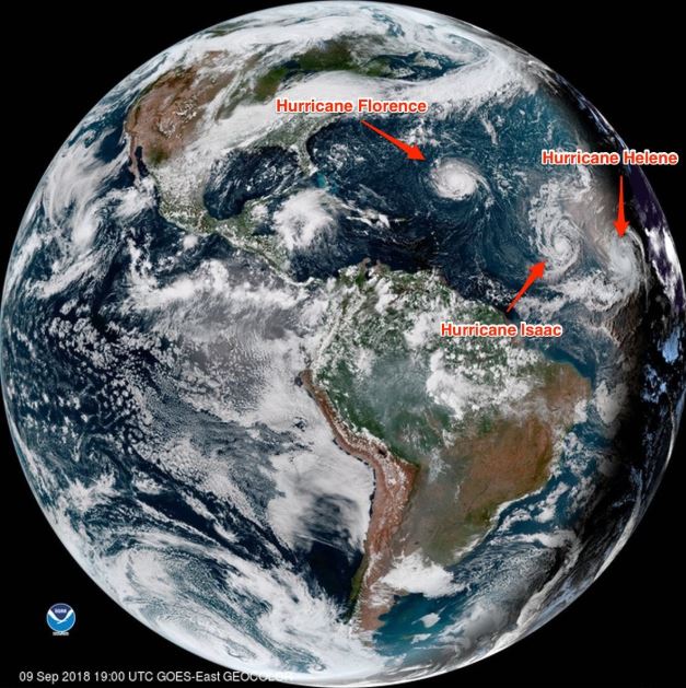 (NOAA)
This article was originally published by Business Insider.
More from Business Insider: