Hurricane Florence may be the strongest storm ever to make landfall north of Florida if predictions hold.
The Category 4 storm is located 905 miles (1456 km) east of Cape Fear, North Carolina and has maximum wind speeds of 130 mph (209 km/h), according to the National Hurricane Center.
Only four Category 4 hurricanes have ever made landfall north of Florida since records were kept, according to The Weather Channel. All of those, however, made landfall south of where Florence is predicted to hit, and Florence's wind speeds are predicted to be higher than those four storms.
Hurricane Hugo, the strongest hurricane ever to impact North Carolina, actually made landfall just north of Charleston, South Carolina in 1989 with 130 mph (209 km/h) winds.
If Hurricane Florence's predicted track holds, it will be the first Category 4 storm to make landfall directly on the North Carolina coast.
The storm will also have stronger winds than Hugo did if Florence strengthens as predicted.
The NHC warned on Tuesday that the storm may strengthen to Category 5, with wind speeds in excess of 157 mph (253 km/h), as it moves over a band of warmer water off of North Carolina's coast.
Warmer ocean water makes hurricanes more intense because the storms are fed by evaporating water. With warmer ocean water, there's more energy available to power the hurricane, according to Nature.
On Wednesday and Thursday, Florence is predicted to move across a band of water that's around 84 degrees Fahrenheit (29 degrees Celsius), which is 3 or 4 degrees Fahrenheit (1.6 to 2.2 degrees Celsius) higher than average for this time of year.
Hurricanes typically need a minimum sea surface temperature of 79 degrees Fahrenheit (26 degrees Celsius), according to The Weather Channel.
The warming ocean temperatures are linked to climate change caused by heat-trapping greenhouse gases in the atmosphere.
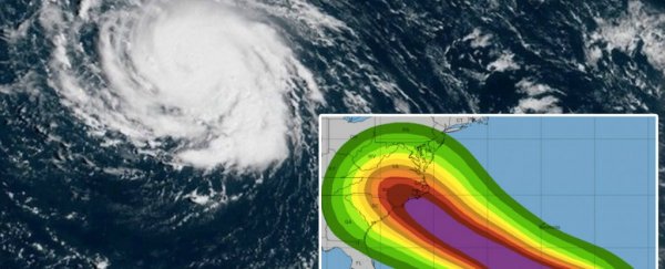
Hurricane Florence is predicted to be the size of the entire state of North Carolina when it makes landfall late Thursday night or early Friday morning.
The storm's 175-mile (282 km) wide "cone of probability" suggests the storm will likely hit North Carolina's coast near Cape Fear, but storms fall outside the cone one-third of the time, according to The Weather Channel.
Category 4 hurricanes are unusual this far north. Hurricanes need warm water to thrive – and the sea surface temperature of ocean water cools as you get further away from the tropics.
The hurricane could inundate low-lying islands off the coast of North Carolina, like the Outer Banks and other barrier islands, according to the NHC.
Heavy rain may extend as far inland as Charlotte, North Carolina's largest city, though the severity will depend on the storm's track, according to The Charlotte Observer.
As of Tuesday morning, close to 1.5 million people were under evacuation orders in South Carolina, North Carolina, and Virginia.
This article was originally published by Business Insider.
More from Business Insider: