Human explorers on the Moon may be able to send back unprecedented, finely detailed maps of the lunar surface, thanks to a new backpack device developed by NASA and its partners.
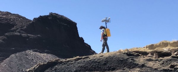
It's called the Kinematic Navigation and Cartography Knapsack (KNaCK for short), and it's equipped with a portable LIDAR scanner that constantly scans the ground as the wearer walks around, collecting detailed information on the surrounding surface topology.
"Basically, the sensor is a surveying tool for both navigation and science mapping, able to create ultra-high-resolution 3D maps at centimeter-level precision and give them a rich scientific context," said planetary scientist Michael Zanetti of NASA's Marshall Space Flight Center.
"It also will help ensure the safety of astronauts and rover vehicles in a GPS-denied environment such as the Moon, identifying actual distances to far-off landmarks and showing explorers in real time how far they've come and how far is left to go to reach their destination."
The system makes use of a technology called Frequency-Modulated Continuous Wave (FMCW) LIDAR. As the name suggests, this sends out a continuous laser beam with a modulated frequency. When this light is reflected off a surface, its frequency changes; when this altered frequency of light returns to the LIDAR detector, it is compared to the emitted light. The difference between the two is proportional to the distance to the surface, and this process generates a detailed topographic map.
This technology does not require the use of fast electronics, and is immune to interference from ambient light. This makes it streamlined and effective, which is what you want for environments like the Moon, one imagines.
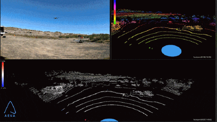 KNaCK technology demonstrated using a drone. (NASA/Michael Zanetti)
KNaCK is able to collect millions of measurement points per second, and even works in the dark, to generate a real-time navigation system that could help astronauts attempting to navigate a hostile, alien environment.
"As human beings, we tend to orient ourselves based on landmarks – a specific building, a grove of trees," Zanetti said.
"Those things don't exist on the Moon. KNaCK will continuously enable explorers traversing the surface to determine their movement, direction, and orientation to distant peaks or to their base of operations. They can even mark specific sites where they found some unique mineral or rock formation, so others can easily return for further study."
Partnering with Torch Technologies Inc. to develop the backpack and Aeva Inc. to supply the LIDAR sensors, NASA has a bit of work to go to further develop the prototype. Field tests have shown that the technology is effective; in November 2021, it was used to map a volcanic crater, and it has also been used to conduct a 3D reconstruction of sea barrier sand dunes at NASA's Kennedy Space Center in Florida.
NASA scientists will continue using KNaCK to assess the impact of storm erosion on the dunes, which currently protect the space agency's primary rocket launch pads. KNaCK is also going to undergo a major field test at NASA's Solar System Exploration Research Virtual Institute in New Mexico.
The technology needs some Moon-proofing, too – to protect it against harsh solar radiation and the lower gravity on the Moon. Work will also be undertaken to shrink the kit. Currently, KNaCk is backpack-sized and weighs about 18 kilograms (40 pounds).
"Taking advantage of the latest advancements in LIDAR technology from Aeva, our next-generation space-hardened unit with support from Torch Technologies will be about the size of a soda can and could enable lunar surface operations like never before," Zanetti said.
That means the astronauts might be able to have actual backpacks that they can fill with Moon rocks or use for something boring, like carrying equipment, while still maintaining mapping-and-navigation functionality.
We're also pretty keen to see what an astronaut falling over might look like in LIDAR data.
NASA's Artemis program aims to return humans to the Moon by 2025.