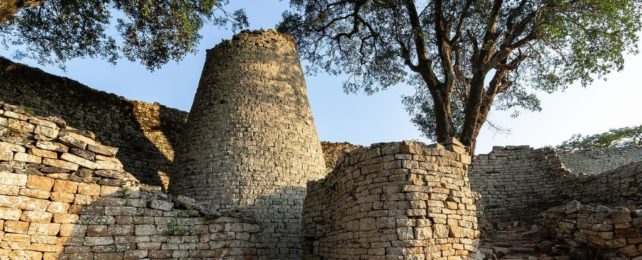
Great Zimbabwe was the first major city in southern Africa, home to an estimated 18,000 people at its peak. Yet no one really knows why it now lies in ruins.
The demise of the once-thriving Medieval metropolis is sometimes boiled down to drought and a drying climate, but archaeologists have now found evidence of careful water conservation amid the wreckage.
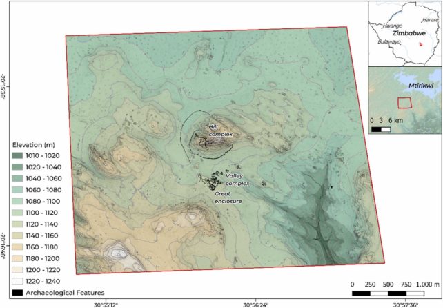
A team of researchers from Denmark, South Africa, England, and Zimbabwe argue that a series of large, circular depressions known as 'dhaka' pits, found around the city, were not used for digging up clay, as experts once thought, but for capturing water.
At the base of several hillsides, for instance, lie numerous dhaka pits, strategically placed to capture rain and groundwater. Other pits surrounding the city straddle streams.
By collecting rainwater and cordoning off some parts of a river or stream, researchers argue the people who once lived here could have ensured water was available for drinking and agriculture through most of the year, even in dry season.
Many of the plant remains found near dhakas, for instance, are known to thrive near rivers or groundwater sources that hold high soil moisture.
The new perspective of Great Zimbabwe's dhaka pits was made possible by using airborne laser scanning to survey the major features of the site, even in places with thick vegetation.
These findings were then complemented by ground surveys and conversations with local communities, who must also conserve water in the arid region.
Figuring out how much water all the dhakas around the city could have once held is imprecise work, especially since this is one of the first studies to really examine the structures. Nevertheless, estimates suggest these pits might have stored over 18 million liters of water.
In the heyday of Great Zimbabwe, between the 11th and 15th centuries, the city was home to ruling elites, religious leaders, craftsmen, and merchants, all of whom would have shared spring water and rainwater in an integrated and flexible system.
During the rainy season, experts say some areas of the city would have become wet and marshy. These locations appear to have been perfect for mining clay to build houses. In drier times, some of these quarries seem to have been turned into reservoirs to collect groundwater and runoff from surrounding hills.
"This partially engineered landscape required maintenance, though organized in a relatively passive manner as runoff was allowed to wash into these basins," the authors write.
"Taken together, the new records show that physical forms, ecological functions, and cultural values of water all shaped, and were shaped by, how communities approached, managed, and conserved water," they add.
Today, very little is known about the history of Great Zimbabwe. It's still possible that the city collapsed due to climate change, even with such a carefully coordinated water system.
During its existence, the world experienced the Medieval Climatic Anomaly and a Little Ice Age, which could have put the growing city under immense stress. But economic or political strains could have also caused its demise.
More research needs to be done before archaeologists can say what happened to southern Africa's first city and its people. Perhaps there's a lesson to be learned in the ruins.
The study was published in Anthropocene.