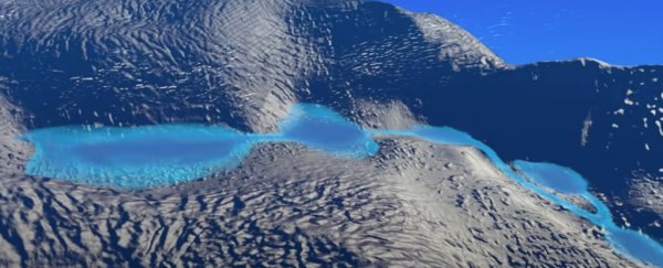
Antarctica may seem like a static environment: a still, white landscape frozen motionlessly into place.
But much more is going on under the ice than we realize – even if you have to travel all the way to space to tell for sure.
Over a decade ago, scientists made just such a discovery, when an analysis of data from NASA's ICESat satellite revealed that variations in ice elevation in West Antarctica reflected a vast mass of subglacial water movement underneath the ice sheet.
Prior to the discovery, it had been thought that hidden meltwater lakes – deeply concealed at the bottom of the ice sheet, where the ice meets the continental bedrock underneath – existed in isolation, cut off from one another.
But in 2007, researchers found that fluctuations in the height of Antarctica's surface ice signified the movement of water flowing between a hidden network of subglacial lakes, which alternately fill and drain before their water escapes to the Southern Ocean.
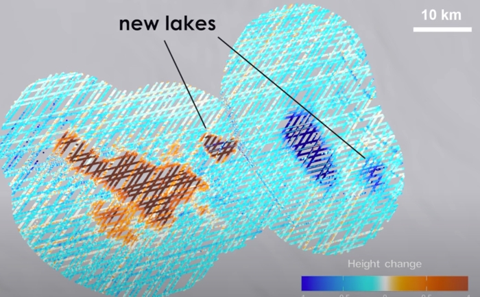 The new lakes discovered. (Siegfried et al./NASA Goddard/YouTube)
Now, the ICESat mission's follow-up – ICESat-2, launched in 2018 – is giving scientists an even keener glimpse at this mysterious, deeply buried lake network, while revealing two lakes never before discovered.
"The discovery of these interconnected systems of lakes at the ice-bed interface that are moving water around, with all these impacts on glaciology, microbiology, and oceanography – that was a big discovery from the ICESat mission," says glaciologist Matthew Siegfried from the Colorado School of Mines.
"ICESat-2 is like putting on your glasses after using ICESat, the data are such high precision that we can really start to map out the lake boundaries on the surface."
In a new study, Siegfried and fellow researchers compiled altimetry data from ICESat-2 and the original ICESat mission, along with measurements taken from CryoSat-2, an ice-observing satellite operated by the European Space Agency (ESA).
By combining the datasets – encompassing the period from 2003 to 2020 – the researchers are able to monitor active subglacial lakes at timescales shorter than ICESat-2's repeat cycle (the 91-day gap before it can observe the same region again).

"Surface deformation due to active subglacial lakes filling and draining provides one of the few remotely accessible windows into the evolution of basal water systems; these systems are otherwise hidden beneath up to 4 km [2.5 miles] of ice and remain one of the major physical uncertainties on projections of future ice sheet dynamics," the researchers write in their paper.
"ICESat-2 laser altimetry can not only extend the record of subglacial lake activity but also provides better understanding of hydrological processes by capturing denser and more precise spatial detail."
In addition to giving us a more detailed look at the activity and outlines of known subglacial lakes in Antarctica – of which there are over 130 already documented – the analysis found two anomalies that appear to be hidden lakes, previously undetected.
These potentially active lakes – called Lower Conway Subglacial Lake (LSLC) and Lower Mercer Subglacial Lake (LSLM), lie near previously discovered lakes, and may have been missed by the original ICESat mission, falling within the narrow gaps between its observations.
In this region – underneath the Mercer and Whillans ice streams in West Antarctica – the lake system, which is dominated by two large active subglacial lakes (Conway Subglacial Lake and Mercer Subglacial Lake), appears to be in the midst of its third drainage event since ICESat observations began in 2003.

Just a few weeks ago, one of the same researchers involved here – glaciologist Helen Fricker from the Scripps Institution of Oceanography – co-authored a related study, detailing a dramatic lake drainage event in East Antarctica, where a surface lake on a floating ice shelf vanished in the space of days.
Far below the ice sheet in West Antarctica, the water draining from subglacial lakes is also thought to eventually flow into the ocean, although the concealed escape route is much harder to visualize.
"These are processes that are going on under Antarctica that we wouldn't have a clue about if we didn't have satellite data," Fricker says.
"We've been struggling with getting good predictions about the future of Antarctica, and instruments like ICESat-2 are helping us observe at the process scale."
The findings are reported in Geophysical Research Letters.