A new map of the Roman Empire's ancient land routes has nearly doubled the length of the confirmed road network, from 190,000 to 300,000 kilometers (118,000 to 186,000 miles).
The publicly available tool – named Itiner-e – represents, at most, just 3 percent of the entire Roman road network, says a team led by archaeologist Tom Brughmans of Aarhus University in Denmark.
Our head journalist, Michelle Starr, spoke to Brughmans about what it took to accomplish this painstaking project, and what challenges remain.
Read the exclusive interview:
- How much of the 'new' network consists of genuinely newly discovered routes, as opposed to higher resolution data of old ones?
This project was in part motivated by my frustration with the lack of open digital access to data. Why have we been studying Roman roads for over 200 years, yet I cannot download anything remotely approximating what we currently know about their location?
The main contribution of the project is that it brings together all of that research about Roman road locations in an open and accountable way: Each of the 14,769 road segments includes the sources used to localize it and an expression of the certainty of the location.
Part of the increase in road length is due to us including much more recent research about Roman roads that came out in the last 25 years.
Read our full story: Massive New Map Reveals 300,000 Km of Ancient Roman Roads
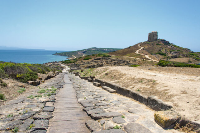
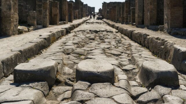
We were able to make a much more detailed map by combining what we know from archaeological excavations, surveys, and the location of milestones along roads, with satellite imagery and historical topographic maps, showing a time before dense urbanization, when Roman roads could have been more visible.
- How much of the actual Roman road network do you think Itiner-e represents?
Our map of Roman roads is just the tip of the iceberg. Roman roads were everywhere the Romans walked, and not just the named main roads. Our dataset includes nearly 200,000 kilometers of secondary roads, but we expect this number can be increased significantly.
We know there are many roads we still haven't found yet because many known ancient places have no roads leading to them. We hope to stimulate future work to improve the open knowledge of where all Roman roads are.
We do not expect to find many more major roads, though. These are the ones the Romans described in travel accounts on how to get from one place to another via roads, and they are very well studied.
- What does it say about Roman roadbuilding that you were able to construct a nearly 300,000-kilometer map of the network thousands of years later?
That's over 7 times the circumference of the Earth. It connected up local road systems into a network that enabled overland travel from Egypt to France.
This period fundamentally restructured transport infrastructure in the region, on a scale unseen until the Industrial Revolution in the 19th century, and we now have the dataset that allows us to study how terrestrial mobility changed over 2,000 years.
- What surprised or excited you most about your findings?
This dataset reveals for the first time that we are certain about the location of only 3 percent of all Roman roads.
This was a huge surprise and a sobering realization: Roads are one of the most enigmatic topics in Roman archaeology and history; they were all over the place. We have proverbs like "all roads lead to Rome".
- What do you think Romans might find surprising about this map?
Rome is not particularly central in the road network. It is located on the Italian peninsula, and its roads are like a linear appendix to the Empire-wide network.
In contrast, areas like the Po Valley up to the Alps near Milan are highly central to road traffic over the entire network. But roads are not particularly efficient for most long-distance travel through the Empire.
Rome's location instead is key when we take major shipping lanes into account, and navigable rivers like the Tiber connecting the city with its main sea ports: Ostia during the republic, and also Portus during the empire. It is spatially very central in the Mediterranean.

- How do you hope other scientists might use this new information?
This new dataset will revolutionize our understanding of how people, ideas, and infectious disease spread 2,000 years ago. Such insights can be used to better understand the challenges we face today.
Ancient pandemics like the Antonine Plague (165-180 CE), the development of early Christianity, and mass migration of Germanic tribes, contributed to the fall of the western Roman Empire (476 CE). These were major events that shaped the history of Europe for the next 2,000 years.
Roads structured how they unfolded and what impact they had.
Read our full article on the discovery here.