For a long time, Hawai'i Island has been home to a mystery. Somehow, the amount of freshwater in underground aquifers has seemed much smaller than it should be, given the amount of rainfall.
Scientists have just found out why. Deep underground, running below the island's coast, vast quantities of freshwater are transported from the flanks of the volcano Hualālai down into newly discovered reservoirs that run deep below the ocean floor.
It's a discovery that has implications for volcanic islands around the world – an untapped potential renewable resource that could prove invaluable as the global climate rapidly changes.
"Our findings provide a paradigm shift from the conventional hydrologic conceptual models that have been vastly used by multiple studies and water organisations in Hawaiʻi and other volcanic islands to calculate sustainable yields and aquifer storage for the past 30 years," said geophysicist Eric Attias of the University of Hawaiʻi.
"We hope that our discovery will enhance future hydrologic models, and consequently, the availability of clean freshwater in volcanic islands."
Most of Hawaii's freshwater is retrieved from aquifers, layers of water-permeable rock or sediment. When rain falls, it percolates through the topsoil and volcanic rock beneath, eventually reaching the deep aquifer reservoirs.
Recent research has suggested that there is far less water in these aquifers than there should be. Studies have found that large quantities of nutrient-rich groundwater are leaking into the ocean, and isotope analyses suggest that there's a huge discrepancy between how much water is going into the aquifers, and how much is retained therein.
To get to the bottom of this discrepancy, Attias and his team turned to electromagnetic imaging.
This is somewhat ingenious, exploiting the conductive properties of salt and fresh water. Freshwater is not very conductive at all. However, the salts dissolved in large amounts in seawater provide plenty of positive and negative ions to transport electrical currents much more efficiently.
The team took a boat along the coastline, towing an electromagnetic system behind them that propagated an electromagnetic field through the water, covering an area 40 kilometres (25 miles) long and 4 kilometres (2.5 miles) wide, producing a trail of electromagnetic data running continuously around 200 kilometres along the coast.
This data revealed regions of higher and lower conductivity along the Kona coastline, allowing the team to map freshwater outflows and their associated reservoirs.
"I have spent my entire career developing marine electromagnetic methods such as the one used here," said geophysicist Steven Constable of the Scripps Institution of Oceanography, who developed the system.
"It is really gratifying to see the equipment being used for such an impactful and important application. Electrical methods have long been used to study groundwater on land, and so it makes sense to extend the application offshore."
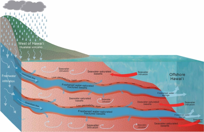 Conceptual model of freshwater path from rainfall to offshore. (Attias et al., Science Advances, 2020)
The team found that there are underground freshwater rivers in layers between saltwater-saturated volcanic basalts. These rivers are around 35 kilometres long extending at least 4 kilometres west of the coastline.
The reservoirs, the researchers estimate, contain around 3.5 cubic kilometres of fresh water - around 1.4 million Olympic swimming pools' worth, and twice as much as previously estimated.
This could change how communities on volcanic islands like Hawai'i deal with a changing climate. The increasing frequency of droughts is likely to decrease the amount of rainfall replenishing the underground aquifers.
Changing the landscape too much can have a negative impact, too; rainforests, for example, help catch the water, channelling the water along plants to a soil layer that retains water and filters it into the ground.
If the forest degrades, this soil layer becomes eroded, and water flows away across the surface, further depleting the aquifers.
The submarine aquifers are more resilient, and could – with careful management to avoid harming local ecosystems – provide a resource to communities living on volcanic islands, in regions such as Galapagos, Comoros, Cape Verde and Reunion.
All these regions have hydrogeological layered formations similar to what Attias' team discovered in Hawai'i. It's possible that they may also have similar freshwater transport mechanisms.
"Such a mechanism may provide alternative renewable resources of freshwater to volcanic islands worldwide where the impacts of climate change decrease water availability," the researchers write in their paper.
"Our findings emphasise the importance of recognising offshore submarine freshened/freshwater groundwater in future aquifer modelling to use water resources of volcanic islands."
The research has been published in Science Advances.