Hurricane Michael, the most powerful storm the US has seen in nearly 50 years, is moving through the Florida Panhandle, ripping apart homes and sending walls of water rushing inland.
The storm made landfall northwest of Mexico Beach around noon on Wednesday, with an eye so clear and wide it could easily be seen from space.
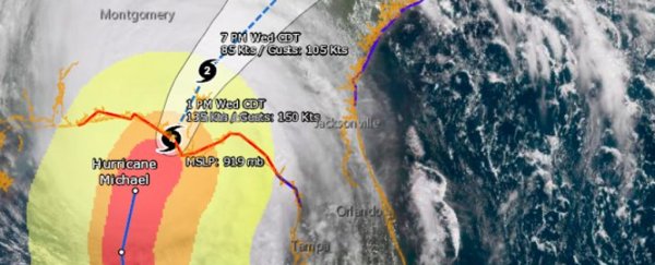
Michael's strong, well-developed core makes for a very powerful, windy storm on land.
Kirsten Fiscus, a journalist, was less than 25 miles (40 kilometres) away in Panama City when Michael's eye made landfall. She said she could smell the pine from snapped tree branches.
I seriously have no words to describe this, it’s awesome but equally terrifying #HurricaneMichael pic.twitter.com/0Y8HQJub1Z
— Kirsten Fiscus (@KDFiscus) October 10, 2018
Richard Fausset of The New York Times said the winds were so intense that it felt like a California earthquake.
Panama City, Fla. This whole hotel is shuddering like it was an LA earthquake. pic.twitter.com/CVA7SrxT2d
— Richard Fausset (@RichardFausset) October 10, 2018
Outside, The Weather Channel's Jim Cantore narrowly missed a flying piece of wood.
Cantore nearly just got speared by 2x4 it seemed. #HurricaneMichael pic.twitter.com/tyNWrymC3p
— Tim Ballisty (@IrishEagle) October 10, 2018
Part of the reason Hurricane Michael became so strong and developed so quickly is that the waters of the Gulf of Mexico are much warmer right now than what's normal for October.
Up the coast in Pensacola, the water temperature is 82 degrees Fahrenheit (28 degrees Celsius) – 8 degrees Fahrenheit (4.4 degrees Celsius) higher than normal for this time of year.
Warmer water acts as fuel for a hurricane, helping it develop into a more destructive, windier storm.
Michael was forecast to bring a storm surge up to 14 feet (4.3 metres) in some areas. Josh Benson, a news anchor at WFLA, a Tampa Bay news station, shared a video taken by Tessa Talarico in Mexico Beach that showed the extreme flooding.
A look at what houses in #Mexico Beach, #Florida look like right now. This is a follow up from the previous clip posted. They are now submerged and were no match for #HurricaneMichael (via Tessa Talarico) #Hurricane #Michael #HurricaneMichael2018 pic.twitter.com/GJENrhFJha
— Josh Benson (@WFLAJosh) October 10, 2018
In Panama City Beach, a building that was still under construction didn't stand a chance against Michael. It quickly buckled under the pressure of the storm.
New construction just collapsed in front of me in Panama City Beach from #hurricanemichael!!! It is going bad fast! pic.twitter.com/CG5R8jcUuf
— Marc Weinberg (@MarcWeinbergWX) October 10, 2018
The hurricane also ripped the roofs off homes.
HURRICANE DESTRUCTION: Hurricane Michael is tearing through Panama City Beach, Florida. Ripping away roofs, flooding condos and throwing debris everywhere. pic.twitter.com/7tuHkPGIvI
— ABC 13 News - WSET (@ABC13News) October 10, 2018
"Where homes were, they are not," Ginger Zee, ABC's chief meteorologist, said in a video posted on Twitter. "It's really wild to see."
Benson also posted a clip of the storm's winds picking up a portable toilet and sending it flying across a parking lot.
LOOK OUT! Watch as this Porta Potty goes flying across the parking lot. Wow. #HurricaneMichael's winds are no joke. (via Jonathan Petramala) #PortaPotty pic.twitter.com/q4YBBYrZIt
— Josh Benson (@WFLAJosh) October 10, 2018
Michael is making its way northeast toward Georgia and the Carolinas at about 14 mph (22.5 km/h). It's expected to gradually weaken over land. By Friday, it should be a post-tropical cyclone,according to the National Hurricane Center.
You can track the hurricane's progress using Google's Crisis Map tool or check for live updates from this National Oceanic and Atmospheric Administration camera in space.
This article was originally published by Business Insider.
More from Business Insider: