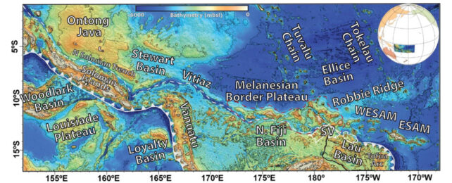
Running for hundreds of miles along the northeastern edge of the Pacific region of Melanesia, the Melanesian Border Plateau is a geological graveyard of dead reefs and failed islands.
The feature is one of countless formations known as large igneous provinces. Such geological superstructures are typically the result of huge volumes of rock bleeding from the endless slide and grind of ocean plate tectonics.
Yet the origin of the Melanesia Border Plateau (MBP) has long lacked detail. A study by an international team of researchers led by University of Nevada geoscientist Kevin Konrad has now uncovered critical evidence on the MBP's formation, which could help us better understand the forces that shape our entire planet.
The superstructure covers around 222,000 square kilometers (85,000 square miles), a little less than the area of the UK.
Scooping material from its surface is enough to show the plateau is igneous in nature, its rocky bones consisting of cooled magma released some time during the Cretaceous Normal Superchron – a period roughly 122 to 83 million years in the past.
But mining evidence off the ocean floor isn't as easy as scouring for clues on dry land. The scarce minerals dredged up over time have suggested the MBP's birth was anything but straightforward, with at least 25 distinct volcanic structures responsible for its generation.
Had the plateau formed in one massive flood of magma, the environmental consequences would have been profound. So knowing more about the steady growth of this volcanic structure could help us better understand everything from climate change to past extinction events.
To discover how the jigsaw-puzzle pieces of surrounding trenches and plateaus interacted over time to create the MBP, Konrad and his team used previously published data on isotope ratios and other forms of geochemistry taken from the plateau and surrounding formations to model the progress of the crust as it passed over high-temperature plumes in the mantle.
Known as hotspots, these intense fountains of heat rise remain relatively fixed as the crust gradually sails across. The result is a blistering column of magma being forced through weaknesses in the rock, generating trails of volcanic activity that splutter chains of islands, mountain ridges, and submerged walls of seamounts.
Putting the pieces together, a vaguely-located plume known as the Louisville hotspot somewhere in the South Pacific laid the MBP's foundations back when dinosaurs still dominated around 120 million years ago, oozing out a torrent of magma that created what is now known as Robbie Ridge, along with a few other surrounding seamounts.
Some 45 million years later, the same weakened section of crust met with a second region known as the Rurutu-Arago hotspot, which saw the rise of new islands and seamounts. Time would drag these back into the depths, yet their roots contributed to the plateau's structure.
A third hotspot responsible for what is now the Samoan Islands would reactivate the formation of seamounts and islands and deliver a new round of volcanic activity some 20 million years ago.
To this day, colossal forces deforming the crust, in part delivered by the rollback of the Pacific plate beneath the Tongan trench, continue to shape the superstructure in a process that shows just how complex the formation of large igneous provinces can be.
The team refers to these hypothetical 'swells' of crust as oceanic mid-plate superstructures.
Knowing just one such superstructure can emerge in pulses as weakened crust sails across tempests anchored in the mantle suggests others might have been formed in similar ways, building slowly and silently rather than in cataclysmic eruptions.
Finding them is going to take new voyages of discovery, sampling the midnight depths for other traces of Earth's hotspots leaving their scars on the surface.
This research was published in Earth and Planetary Science Letters.