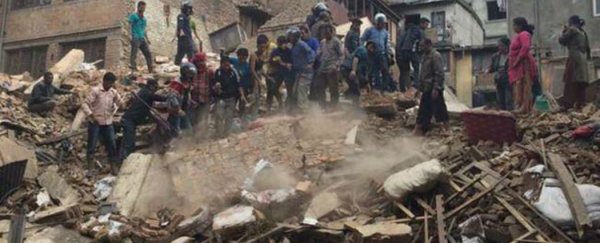
It doesn't matter how well-trained and prepared an aid worker is, if they don't know the lay of the land where they're working, such as where the local pharmacies, supermarkets, major roads, and hospitals are, there's not a whole lot they can do in situations like the aftermath of the Nepal earthquake.
So a team of tech experts set up the Humanitarian OpenStreetMap Team (HOT), nicknamed 'the Wikimedia of maps', which allows the public to use aerial images of a region affected by a disaster to remotely map things like roads, buildings, shops, water wells, and perfect spots for supply helicopters to land. This means that not only will aid workers be able to move around more quickly, but they will be able to better predict where injured people might be located.
So far, thousands of volunteers have already been mapping data points, and the team at HOT says they've been building maps of most of Kathmandu, the capital city of Nepal. "Half of our mission is response to crises like this, so when something awful happens we can jump on it and start giving them data they need," Blake Girardot, activation coordinator of HOT, told Adele Peters at Fast Company. "But the other half of the equation is preparing for these disasters. It's not a mystery where vulnerable places are. In places with earthquakes, floods, drought, or political conflict, we can start identifying those places ahead of time and start doing mapping before the crisis happens."
The team has actually been working on mapping Kathmandu since 2013, when Nepal was ranked as the fourth most climate-vulnerable country in the world by the World Bank, as it's highly exposed to a range of water-related hazards such as floods, droughts and landslides. The April 25 earthquake has obviously made things a whole lot more urgent, so they're calling for more volunteers to join the effort now.
Girardot says this isn't one of those projects where volunteers find it difficult to see how their efforts are being used, and you can get trained via an online training course in less than an hour. "Seventy two hours after this happened, thousands of people who are amateurs at this or brand new to it have mapped something like 100,000 buildings," he told Peters at Fast Company. "That initial data is super useful - it's 80 percent of what we need. Then we'll spend the next weeks refining it back to very high-quality data."
This 'high-quality data' Girardot is referring to means the difference between a paved or an unpaved road - little details that make life that much easier for aid workers on the ground. He adds that even 10 minutes of clicking - which can be a bit monotonous, but for a good cause! - can contribute important data points to their maps.
"Any mapping that people can contribute helps," he told Fast Company. "It matters. It's surprising that it matters so much, but it matters. Every click turns into a data point. You do 20 clicks, that's three buildings that nobody knew about, nobody had access to until you put it in there. Now suddenly those things are on the map."
You can find out more about HOT, and sign up to get started, by clicking here.
This recently shot drone footage in Nepal gives you an idea of the destruction the people there are faced with:

Source: Fast Company