Archaeologists have encountered a mysterious structure beneath the ruins of an ancient city while testing out some new scanning equipment in the northwest Nile Delta of Egypt.
The ancient city has held many names in the nearly 6,000 years since it was established. Ancient Egyptians named it Per-Wadjet, as it was a site sacred to their snake goddess Wadjet; during ancient Greek occupation of Egypt, beginning 305 BCE, it was called Buto; now, the site of the city's ruins holds the Arabic name Tell el-Fara'in, meaning 'Hill of the Pharaohs'.
The city's long history saw its structures built, destroyed, and rebuilt until around the 7th century CE, when it fell into ruin.
The layers of material left behind by Buto's many occupants make it a site archaeologists are eager to probe. Still, mud deposits, groundwater, and the site's size and depth have made traditional digs somewhat daunting.
By enlisting modern technology, in the form of satellite radar and electrical resistivity tomography (ERT), a team led by archaeologist Mohamed Abouarab of Kafrelsheikh University in Egypt has been able to peer within the layers to find where – and what – might be worth rolling their sleeves up for.
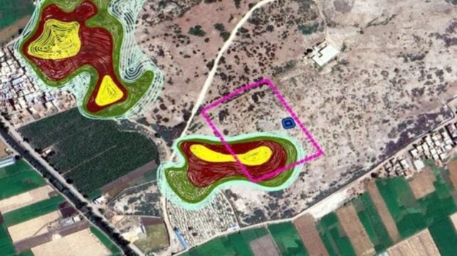
Using imagery captured by radar satellite Sentinel-1 in 2018, the team identified large-scale anomalies on the surface of the site that might indicate buried structures and warrant further investigation.
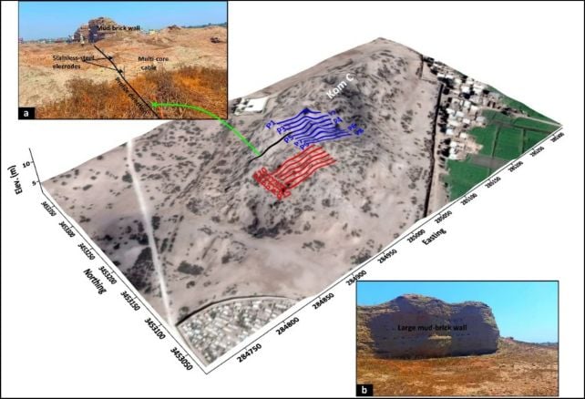
After detecting 15 decent candidates to profile at a site named Kom C, they proceeded with the ERT. They placed 24 stainless steel electrodes along a 69-meter (226-foot) cable laid into the ground at each site of interest.
These electrodes send electrical currents into the ground, and then the amount of resistance or conduction the currents encounter can be used to get a sense of what's down there – a bit like a very large-scale CT scan of the ground.
This process resulted in 1,332 resistivity readings across Kom C, which revealed a mysterious, partially buried mudbrick structure, roughly 25 by 20 meters (82 by 65 feet) in area, buried 3 to 6 meters below ground, under layers of broken pottery and rubble laid down during the later Roman and Ptolemaic periods, from around 332 BCE to 395 CE.
"3D inversion algorithms were particularly effective in delineating buried mudbrick walls and architectural structures, significantly enhancing our understanding of site formation processes," the team notes.
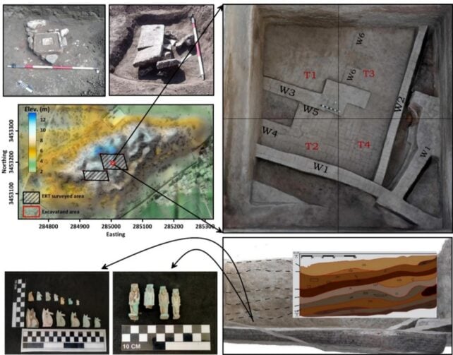
Subsequent excavations confirmed what the scans detected. The structure is around 2,600 years old, dating it to the Saite period: the 26th and final dynasty of ancient Egyptian rule before the Persian conquest of 525 BCE.
The archaeologists uncovered the mudbrick walls, along with a collection of amulets and other 26th-dynasty objects, including an intriguing, hybrid figure combining elements of a baboon, a falcon, and a Patikos (a dwarf god).
Other amulets depicted better-known Egyptian deities, including Isis, Horus, Taweret, and of course, the goddess Wadjet of Buto.
With all these spiritual artifacts, the archaeologists suspect the building may have served a religious purpose.

"The presence of amulets, altar, and other ritual objects suggests that the site may have functioned as a temple, a religious service complex of some kind, including a mortuary function, or a priestly residence," they report.
"However, determining the precise function of these structures remains challenging at this stage. A clearer understanding of their nature is expected to emerge as excavations progress in future seasons."
Related: Scientists Are 'Sniffing' Ancient Egyptian Mummies. Here's Why.
It's a very successful first run for the scanning technique, which Abouarab and his team plan to extend further to older depths of the site.
"The results of this study demonstrate the effectiveness of combining geophysical measurements and remote sensing data, which gave a very accurate vision in detecting buried settlements in a complex region," the team writes.
"Our findings suggest that, in addition to the known temple, another temple may remain buried under a thick clay layer, which will be investigated through extensive measurements in forthcoming studies."
The research was published in Acta Geophysica.