
The engines driving the growth of the world's highest mountains into the sky run deep beneath the planet's skin. Geologists have some idea of the mechanisms at work, but evidence has so far left plenty of room for debate over the details.
Combined with a fresh look at previous research, a recent analysis of new seismic data collected from across southern Tibet has delivered a surprising depiction of the titanic forces operating below the Himalayas.
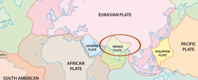
Presenting at the American Geophysical Union conference in San Francisco last December, researchers from institutions in the US and China described a disintegration of the Indian continental plate as it grinds along the basement of the Eurasian tectonic plate that sits atop it.
It's a surprising compromise on two models currently favored as explanations for the lifting of the Tibetan plateau and the colossal Himalayan mountain range.
In both cases, a collision between the chunks of crust belonging to India and Eurasia is responsible. Starting around 60 million years ago, the Indian plate was driven beneath its northern neighbor as it was carried along by currents of molten rock within the mantle.
Bit by bit, the Eurasian land mass has been lifted skyward on the shoulders of a drowned giant, giving us Earth's highest elevations.
Studies of the density of the mantle and the crust suggest the rather buoyant Indian continental plate shouldn't sink so easily, however, meaning it's likely the submerged sections of the crust should still be grinding along under the belly of the Eurasian plate rather than being plunged into the mantle's depths.
Another possibility is the Indian plate is distorting in a way that causes some parts to wrinkle and fold, and others to dip and dive.
Different perspectives emerge depending on which kinds of evidence are favored and how data is processed.
In an investigation led by Ocean University of China geophysicist Lin Liu, researchers amassed 'up-and-down' S-wave and shear-wave splitting data from 94 broadband seismic stations arranged west-to-east across southern Tibet, and combined it with previously collected 'back-and-forth' P-wave data to come up with a more nuanced view of the dynamics below.
They determined the Indian slab wasn't merely bobbing along smoothly below the Eurasian plate, nor was it bunching up like a rug on a slippery floor.
Instead it is delaminating, with its dense base peeling free and sinking into the mantle as its lighter top-half continued its journey just beneath the surface.
While computer models had suggested thicker sections of some plates could come apart like this, the study provides the first empirical evidence of it occurring.
The team's description is consistent with geological models based on limits of helium-3 enriched spring water and patterns of fractures and earthquakes near the surface, which taken together support a map of carnage below, where sections of the old Indian plate seem more or less intact, and others are stripping apart around 100 kilometers below, allowing the base to warp into the planet's molten heart.
Having a clear 3D description of the boundaries and borders of plates as they grind together not only makes it easier to understand how our surface came to look as it does, but could inform future methods of earthquake prediction.
The study was presented at the 2023 American Geophysical Union conference. A pre-print copy of the study is available online.