The biggest natural disasters are by no means just a local issue, as new research shows: smoke from the devastating California wildfires of 2020 eventually reached as far as Europe, and was still dense enough after its travels to block out the Sun.
Scientists tracked wildfire smoke originating from the US west coast in September 2020 through a combination of ground readings and satellite imagery to investigate the plumes' path in detail. At the time, it took just a few days for the smoke to make its way across North America and the Atlantic, carried by jet stream currents.
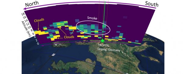
Measurements made in Leipzig in Germany showed that the passing smoke was thick enough to reduce the amount of sunlight reaching the ground by a third. Scientists here had the necessary ground kit to be able to verify the readings coming from satellites.
"Due to the prevailing winds, the travel time of the smoke from the US West Coast to Europe was only about 3 to 4 days," says meteorologist Martin Radenz, from the Leibniz Institute for Tropospheric Research (TROPOS) in Germany.
"The air masses even made the approximately 3,000 kilometers [1,865 miles] across the Atlantic Ocean between Newfoundland and Ireland at high speed in only one day."
The research shows off the capabilities of the Aeolus satellite, launched by the European Space Agency (ESA) in 2018. Not only can the satellite's instruments measure global wind currents, they can also monitor aerosols in the atmosphere.
It does this through LIDAR (light radar technology), with a high-performance laser trained on the atmosphere. Through the change in frequencies as the laser light is reflected, vertical wind speed can be measured – with the ability to measure aerosols a welcome bonus for scientists.
The smoke measured in the troposphere (the lowest level of the atmosphere) between 4 kilometers (2.5 miles) and 11 kilometers (6.8 miles) off the ground was averaged out at 8 micrograms per cubic meter, and peaked at 22 micrograms – a "quite remarkable" level according to the scientists.
"Using revolutionary laser technology, Aeolus is currently the only satellite in the world that can measure profiles of horizontal wind speed as well as the backscatter and extinction of aerosols and clouds independently," says meteorologist Sebastian Bley, from TROPOS.
"The satellite thus provides valuable information on the radiative properties of these smoke aerosols."
Using a complex backwards simulation model, the team was able to demonstrate that the smoke swirling above Leipzig had indeed come from the west coast of the US, with smoke from smaller fires in Oregon, Washington and Montana mixing in with the blazes coming from California.
As previous studies have noted, wildfire smoke can clog up the atmosphere in a similar way to a volcanic eruption, making it vital that we find ways of minimizing the risk of these fires getting started in the first place. Even in May 2021, the wildfires had not been fully extinguished.
With advanced measurement tools like the ones on board Aeolus now available to experts, we should at least be able to get a better idea of what's happening in our atmosphere, and what might happen next.
"It is expected that this unique configuration will contribute to improved predictions of such global smoke dispersion but also of weather in general," says Bley.
The research has been published in Geophysical Research Letters.