A new study has shown how ancient civilizations in central Mexico might have once used specific features of their rugged landscape to mark key points in the seasons, allowing them to plan the planting of crops needed to keep a thriving population of millions alive and well.
Led by University of California, Riverside plant ecologist Exequiel Ezcurra, the research validates speculations that the jagged horizon peaks of Mount Tlaloc served as a way to monitor the agricultural calendar to match the seasons as per the passing of each solar year.
In the spring, the Mexico Valley is hot and dry. Come summer and early fall, it is monsoon season. The annual cycle of wet and dry means that crops must be planted at very specific times. Otherwise, the entire harvest can be undermined.
"Planting too early, following the cue of a first haphazard early rain, can be disastrous if the true rainy season does not continue," explain Ezcurra and his fellow researchers.
"Waiting to plant late, after the monsoon season has clearly started, can expose the corn field, or milpa, to an overly short growing season and will also put the crop under competition from weeds that have already germinated."
Plenty of civilizations have used cues on the horizon to mark how the Sun moves through the sky. For instance, the oldest solar observatory in the world is composed of a line of 13 stone towers, which were built by an unknown civilization in Peru more than 2,300 years ago.
When the Sun rises or sets in the space between each tower, it represents the passing of a specific amount of time. The huge 'clock' is so accurate, it can predict the exact time of year give or take two or three days.
A similar design would have been used in the Basin of Mexico, Ezcurra and his team suggests. Except in this case, the Sun markers were not constructed. Instead, they were simply chosen from features set in the natural landscape.
"In order to adjust their calendar, the Mexica would have needed to know the position of the Sun on particular dates of the solar year, a feat that could have been accomplished only by marking the sunrise (or sunset) bearing relative to a geographic landmark," the researchers argue.
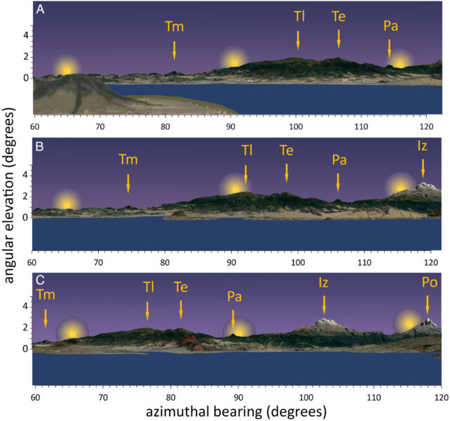
The orientation of specific buildings in the valley, like Mexico City's sacred Templo Mayor, would have been designed specifically so that the Sun could be watched from a fixed point as it crosses the horizon. Other peaks, like Mount Tepeyac, might have provided alternative lookouts.
Standing on the top of Templo Mayor on the winter solstice, an observer would see the Sun rise just behind the tip of Mount Tehuicocone. On the summer solstice from this same viewpoint, they would see the Sun rise right behind the present-day archeological site of Tepetlaoxtoc, which sits 2,300 meters (about 7,500 feet) above sea level in the foothills of a mountain chain called Sierra de Patlachique.
Solstices would also be marked by a pause in the Sun's progress along the horizon, rising and setting behind the same landmarks for a period of around 10 days.
Equinoxes were probably also observed from the top of Templo Mayor. The March and September equinoxes, for instance, are marked by the Sun rising behind the peak of Mount Tlaloc.
Ezcurra and his team calculated there is only one day in spring and one day in fall when the Sun rises directly behind this mountain, making it a highly accurate form of timekeeping.
Taken together, the alignments – along with illustrations and texts found in ancient Mexica codices – imply Mount Tlaloc served as a fundamental tool for marking important times of the year and for calendric adjustments. With this approach, the Sun would rise directly behind Mount Tlaloc every 365 days, and every four years, an extra day would have to be accounted for to keep the calendar on track.
Researchers at UCR have shown that this natural timekeeping device is mathematically possible, but whether or not ancient people in the Mexico Valley actually relied on this technique is uncertain.
Some historical records from colonists hint at the Aztec calendar starting in February, but they also suggest that important rituals and sacred ceremonies occurred around the same time that the Sun rises behind key landmarks in the valley.
During the driest part of the spring equinox, for instance, the Sun rises behind Mount Tlaloc, named after the god of water and rain.
The summer solstice, meanwhile, is a celebration of salt and summer corn, and it occurs when the Sun rises behind the salty shores of Lake Texcoco.
Finally, the winter equinox occurs when the Sun rises at the edge of a landscape feature known as Iztaccihuatl which looks like a sleeping woman. This time of year is also associated with womanhood and female gods.
If the Sun's position relative to Mount Tlaloc is as significant as it seems, how might it have been used as a marker for the start of the year?
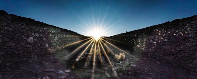
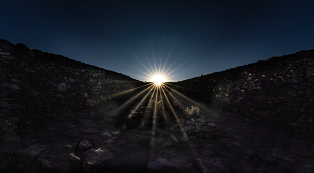
The remnants of a raised road, leading up the mountain's slope might hold the answer. The curious thing about this road is that is built at a shallow angle, leading out of a rectangular walled enclosure as can be seen in the image below.
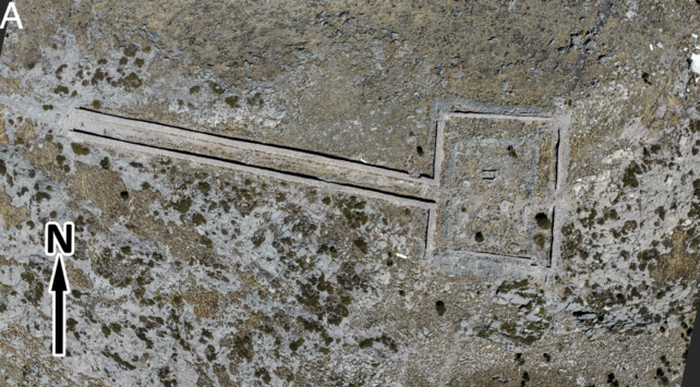
Researchers think it might be intentionally misaligned so that the Sun sets right between the walls bordering the road, as seen when looking upslope.
The day the Sun is framed in this beautiful way occurs on February 23 or 24, the beginning of the Mexica solar year.
"These results confirm that, even without the celestial instruments used by Europeans at the time of their arrival … the people in the Basin of Mexico could maintain an extremely precise calendar that would have allowed for leap-year adjustments simply by using systematic observations of sunrise against the eastern mountains of the Basin of Mexico," researchers conclude.
The study was published in PNAS.