In September 2023, Earth rumbled.
Seismic monitoring all over the globe registered a strange signal that repeated every 90 seconds over a whopping nine days, petering out in a way never before seen.
Then the same thing happened a month later. Subsequent analysis of those signals determined that the cause of that trembling was likely a giant megatsunami rocking back and forth, slapping against the sides of a fjord in Greenland – generating a standing wave known as a seiche.
Now, scientists have finally actually seen the event, in satellite data captured while the event was in progress. It's the observation needed to confirm that the cause of the seismic signal was indeed a seiche, giving us an answer to the age-old question: if a seiche forms in a Greenland fjord and no one is around to see it, does it shake the planet?
"This study is an example of how the next generation of satellite data can resolve phenomena that has remained a mystery in the past," says ocean engineer Thomas Adcock of the University of Oxford in the UK.
"We will be able to get new insights into ocean extremes such as tsunamis, storm surges, and freak waves. However, to get the most out of these data we will need to innovate and use both machine learning and our knowledge of ocean physics to interpret our new results."
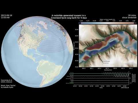
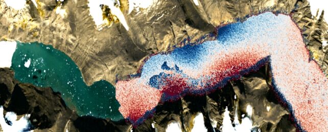
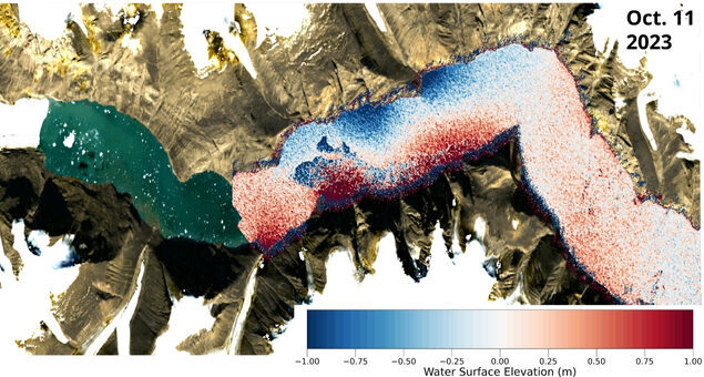
According to the analysis of the seismic data, the trigger that unleashed the megatsunami was a melting glacier that sent two giant landslides toppling into the remote Dickson fjord in East Greenland. The resulting splashes generated powerful tsunamis that, with nowhere else to go, sloshed back and forth for days, reaching a peak height of 7.4 to 8.8 meters (24.3 to 28.9 feet).
Because of the remote location, however, no one actually saw either event – not even a military vessel that visited the fjord three days into the first one.
But humanity has eyes in the sky. There's a satellite mapping technique called altimetry that measures the height of the surface of the planet (including bodies of water) based on how long it takes a radar signal to travel down to the surface and bounce back up again.
Most altimetry measurements were unable to record the seiches, because the resolution isn't high enough and the measurements are taken too far apart in time. But a NASA mission launched in 2022 called the Surface Water Ocean Topography (SWOT) satellite has an instrument that is able to take measurements of the height of water with unprecedented precision.
The satellite just so happened to have taken measurements at intervals during the days following both events. So the researchers on the new study used this data, collected by SWOT's Ka-band Radar Interferometer, to compile elevation maps of the fjord.
Their results showed clear and significant height variations in the water, which was rising as a 2-meter standing wave reverberating back and forth across the fjord.
That was it: the team had finally laid eyes on the seiches that were thought to have sent such strange signals rumbling around the world.
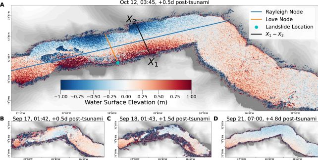
The next step was to link the two phenomena. By comparing their observations to seismic data, the researchers were able to reconstruct the characteristics of each wave, and the evolution of each event, even for time periods that the satellite had not observed. They were able to rule out other possible explanations for the seismic signals, and confirm that the seiches were responsible.
It's a beautifully tidy result that will help us study such events in the future.
"Climate change is giving rise to new, unseen extremes. These extremes are changing the fastest in remote areas, such as the Arctic, where our ability to measure them using physical sensors is limited," says engineer Thomas Monahan of the University of Oxford.
"This study shows how we can leverage the next generation of satellite Earth observation technologies to study these processes. SWOT is a game changer for studying oceanic processes in regions such as fjords which previous satellites struggled to see into."
The research has been published in Nature Communications.