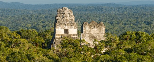
Pyramids peek above the canopy of the Guatemalan jungle in Central America, but the roots of the ruins run a lot deeper than it looks.
A LIDAR ("light" and "radar") survey of the area has revealed 60,000 previously unknown structures - suggesting a vast megalopolis that was home to millions more people than previously thought.
Mapping a 2,100 square kilometre (800 square mile) area of jungle around the Lost World city of Tikal - a popular tourist destination - a team of researchers found palaces, bridges, fortifications, dwellings, and other human-made features that have been lost for centuries.
The city is enormous - three to four times larger than previously thought.
"The LIDAR images make it clear that this entire region was a settlement system whose scale and population density had been grossly underestimated," Thomas Garrison, an Ithaca College archaeologist told National Geographic.
As digital technology becomes more sophisticated, it is growing increasingly useful for research. LIDAR in particular has been growing increasingly popular in archaeological field studies. It uses lasers as a type of radar to create 3D maps, and it's particularly useful since it can penetrate foliage and water.
Previous LIDAR surveys have found huge medieval cities under the jungles of Cambodia, and the remnants of Iron Age structures in Britain.
The Tikal survey, led by the PACUNAM Foundation focusing on research and conservation in the Maya Biosphere Reserve, is the largest archaeological survey using LIDAR to date.
The interconnected network of ancient Maya cities was home to millions more people than previously thought https://t.co/0E0FafOyRR
— National Geographic (@NatGeo) February 1, 2018
The results suggest a complex, highly sophisticated civilisation 1,200 years ago, led by the mysterious Snake Kings that rose from obscurity to conquer the Maya world.
It was, the researchers believe, very different from the civilisation of sparsely scattered city-states previously conceived from ground-based research, and more comparable to cultures such as ancient Greece, or China.
The new estimates put the population at around 20 million people across the Maya lowlands, about half the population of the entirety of Europe at the time in an area around the size of Italy.
Among the discoveries were raised highways, connecting almost all the urban centres, as well as urban centres to quarries. They were elevated to allow easy access during rainy weather, and their width suggests they were heavily trafficked and used for trade.
The researchers also found complex irrigation and terracing systems, suggesting sophisticated agriculture helped keep the populations fed. Canals, dykes and reservoirs kept the jungle's wetness under control, and fortifications suggest that warfare was an important and ongoing concern.
"We've had this western conceit that complex civilisations can't flourish in the tropics, that the tropics are where civilisations go to die," Marcello Canuto, a Tulane University archaeologist, told National Geographic.
"But with the new LIDAR-based evidence from Central America and [Cambodia's] Angkor Wat, we now have to consider that complex societies may have formed in the tropics and made their way outward from there."
The survey was just the first part of the PACUNAM Foundation's project, and the researchers believe there is a lot more yet to be uncovered.
"There are entire cities we didn't know about now showing up in the survey data," said Boston University archaeologist Francisco Estrada-Belli.
"There are 20,000 square kilometres more to be explored and there are going to be hundreds of cities in there that we don't know about. I guarantee you."