In the autumn of 1929, Anne Morrow Lindbergh and her husband Charles flew across the Yucatán Peninsula. With Charles at the controls, Anne snapped photographs of the jungles just below.
She wrote in her journal of Maya structures obscured by large humps of vegetation. A bright stone wall peeked through the leaves, "unspeakably alone and majestic and desolate - the mark of a great civilization gone."
Nearly a century later, surveyors once again took flight over the ancient Maya empire, and mapped the Guatemala forests with lasers.
The 2016 survey, whose first results were published this week in the journal Science, comprises a dozen plots covering 830 square miles, an area larger than the island of Maui. It is the largest such survey of the Maya region, ever.
The study authors describe the results as a revelation. "It's like putting glasses on when your eyesight is blurry," said study author Mary Jane Acuña, director of El Tintal Archaeological Project in Guatemala.
In the past, archaeologists had argued that small, disconnected city-states dotted the Maya lowlands, though that conception is falling out of favor.
This study shows that the Maya could extensively "exploit and manipulate" their environment and geography, Acuña said. Maya agriculture sustained large populations, who in turn forged relationships across the region.
Combing through the scans, Acuña and her colleagues, an international 18-strong scientific team, tallied 61,480 structures. These included: 60 miles of causeways, roads and canals that connected cities; large maize farms; houses large and small; and, surprisingly, defensive fortifications that suggest the Maya came under attack from the west of Central America.
"We were all humbled," said Tulane University anthropologist Marcello Canuto, the study's lead author.
"All of us saw things we had walked over and we realized, oh wow, we totally missed that."
Preliminary images from the survey went public in February, to the delight of archaeologists like Sarah Parcak. Parcak, who was not involved with the research, wrote on Twitter, "Hey all: you realize that researchers just used lasers to find *60,000* new sites in Guatemala?!? This is HOLY [expletive] territory."
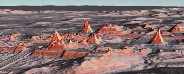
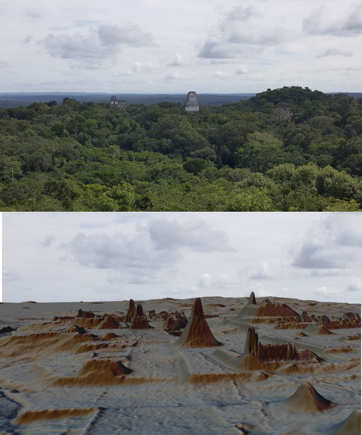 What lidar can reveal. (Luke Auld-Thomas and Marcello A. Canuto/PACUNAM)
Parcak, whose space archaeology program GlobalXplorer.org has been described as the love child of Google Earth and Indiana Jones, is a champion of using satellite data to remotely observe sites in Egypt and elsewhere.
"The scale of information that we're able to collect now is unprecedented," Parcak said, adding that this survey is "going to upend long-held theories about ancient Maya society."
With support from a Guatemala-based heritage foundation called Pacunam, the researchers conducted the massive and expensive survey using lidar, or light detection and ranging. They mapped several active archaeological sites, plus well-studied Maya cities like Tikal and Uaxactun.
Lidar's principles are similar to radar, except instead of radio waves lidar relies on laser light. From an aircraft flying just a few thousand feet above the canopy, the surveyors prickled each square meter with 15 laser pulses. Those pulses penetrate vegetation but bounce back from hard stone surfaces. Using lidar, you can't see the forest through the invisible trees.
Beneath the thick jungle, ruins appeared. Lots and lots of them.
Extrapolated over the 36,700 square miles, which encompasses the total Maya lowland region, the authors estimate the Maya built as many as 2.7 million structures. These would have supported 7 million to 11 million people during the Classic Period of Maya civilization, around the years 650 to 800, in line with other Maya population estimates.
"We've been working in this area for over a century," Canuto said. "It's not terra incognita, but we didn't have a good appreciation for what was really there."
Archaeologist Arlen Chase, a Maya specialist at the University of Nevada at Las Vegas who was not involved with this survey, said for years he has argued that the Maya society was more complex than widely accepted.
In 1998, he and archaeologist Diane Chase, his wife, described elaborate agricultural terraces at the Maya city of Caracol in Belize. "Everybody would not believe we had terraces!" he said.
He gets much less push back now, he said. "The paradigm shift that we've predicted was happening is in fact happening" Chase said, which he credits to lidar data. He has seen lidar evolve from a "hush-hush type of technology" used by the military to map Fallujah streets to a powerful archaeological tool.
Chase, who previously used lidar at Caracol, where as many as 100,000 people lived, compares this technology to carbon-14 dating. Radiocarbon dating gives archaeologists a much more accurate timeline.
Lidar is about to do the same for archaeologists' sense of space, particularly in densely forested areas near the equator. Two years ago, researchers used lidar mapped dense urban infrastructure around Angkor, the seat of the medieval Khmer Empire in Cambodia.
"We're just getting started in so many major sites around the world, whether it's Angkor Wat, whether it's Tikal in Central America or major sites in Egypt," Parcak said.
For all its power, lidar cannot supplant old-fashioned archaeology. For 8 percent of the survey area, the archaeologists confirmed the lidar data with boots-on-the-ground visits.
This "ground truthing" suggests that the lidar analysis was conservative - they found the predicted structures, and then some.
"There is still much more ground to cover and work to do," said Acuña, who will continue to study the large ancient Maya city of El Tindal.
Could you imagine, Canuto said, what might be found through a lidar survey of the Amazon? With technology like this, no forested frontiers are final.
2018 © The Washington Post
This article was originally published by The Washington Post.