
It's not just rising sea levels that we need to worry about: In many parts of the world, the ground is subsiding beneath our feet too.
Sinking land can happen just about anywhere, both naturally and due to human interference with ecosystems and landscapes.
However, it has the potential to be particularly damaging around the coasts, where drops in the ground level increase the risk of flooding and infrastructure damage.
To get a more comprehensive idea of this problem along the United States coastline, researchers from Tufts University and Virginia Tech analyzed more than 190 million data points measuring vertical land motion (the rising or falling of Earth's surface over time).
These measurements were mostly taken via satellites in orbit, bouncing radar signals up and down to gauge the level of the land. Across the period 2007 to 2020, the data showed widespread coastal subsidence.
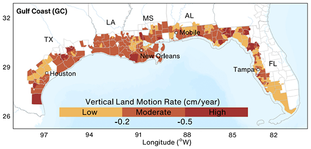
"Nationally, 71.5 percent of coastal areas subside faster than 0.1 centimeters (0.04 inches) per year, with the Gulf Coast experiencing the highest rates," write the researchers in their published paper.
"These findings offer a foundation for resilient coastal planning and equitable adaptation of infrastructure systems."
Close to half of the US coast (43 percent) was found to be sinking by 0.2 centimeters (0.08 inches) or more a year, while almost a quarter (23.3 percent) registered subsidence of at least 0.3 centimeters (0.12 inches) a year.
While sinking was most pronounced on the Gulf Coast to the south of the US, it was "near-ubiquitous" along the East Coast too, the researchers found. Some uplift was recorded, but mostly along the West Coast.
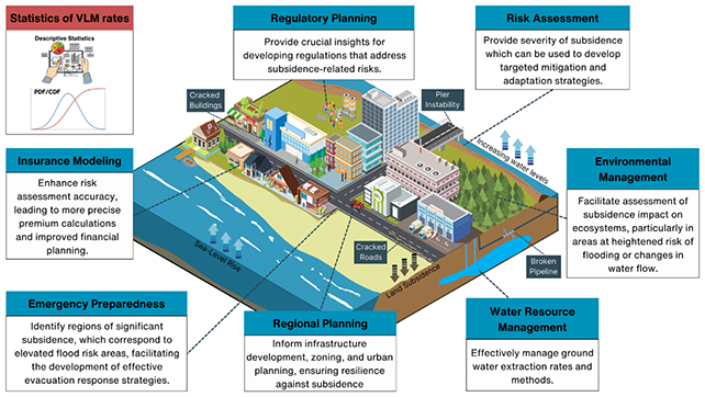
That means there's not a one-size-fits-all solution to tackling the problem: What needs fixing and how depends on regional factors.
"Land subsidence does not occur in isolation," write the researchers. "It often interacts with climate extremes and human land use, creating feedback loops that can amplify both hazards and vulnerabilities.
"Although subsidence typically occurs slowly, its cumulative effects can be devastating over time."
The study points to several reasons for the coastal subsidence. Some are natural geological processes: the natural compaction of soft sediment in areas such as deltas and wetlands, and even ongoing geological settling from the last Ice Age (technically 'glacial isostatic adjustment'), for example.
Other reasons are very much to do with our influence, like the excessive pumping out of groundwater to supply populations, industries, and agriculture. However, this wasn't something the researchers assessed directly here.
The researchers also looked at how many people it could potentially affect. The estimates are around 67.1 million in low-subsidence areas, 14 million in moderate-subsidence areas, and 3.2 million in high-subsidence areas.
"The exposure analysis reveals that approximately 84.3 million people across US coastal census tracts live in areas affected by varying levels of land subsidence," write the researchers.
Citing Hurricane Katrina as a recent example, the researchers note that sinking land can reduce the effectiveness of levees, sea walls, and drainage systems, and put extra stress on infrastructure – roads, bridges, buildings, and pipelines.
What's more, those facing the greatest risk and potential losses are often also those least able to adapt. People at the margins of society are often hit hardest, and are less able to recover from events like flooding – meaning the effects are compounded over time.
The researchers want to see further scientific study of the subsidence problem, as well as subsidence data incorporated into coastal planning and infrastructure investment decisions so communities are better able to cope with it.
"This study establishes the first national-scale, statistically grounded assessment of coastal land-subsidence hazards and inequities in the US, providing a scalable foundation that can be updated as new data become available," write the researchers.
The research has been published in Communications Earth & Environment.
This article was fact-checked by Peter Dockrill and edited by Peter Dockrill. While we pride ourselves on our process, we are only human. If you spot a mistake, please let us know.