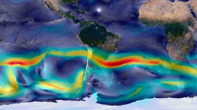
Unseen rivers are surging through the sky, nourishing the world with an "invisible yet vital" source of atmospheric moisture that falls as rain.
Aerial rivers, also known as sky rivers or flying rivers, are much more hydrologically influential than their smaller but potentially more well-known siblings, atmospheric rivers, which are episodic and short-lived.
In contrast, aerial rivers are persistent confluences of moisture transport pathways in the atmosphere that embody the cumulative effects of wind, from sea breezes to low-level jets, and the aforementioned atmospheric rivers.
They sustain ecosystems on climatological timescales and traverse the globe. Previous research, for example, traced the moisture pathways that supply Pakistan and found they extend from Scandinavia to Madagascar.
Mapping – and then managing – these sky-borne sprinkler systems is increasingly crucial for water sustainability in a world experiencing the warming, drying effects of climate change.
So, in an expansive new study, researchers used mathematical modeling and observational climate data to analyze the aerial river systems that sustain South America.
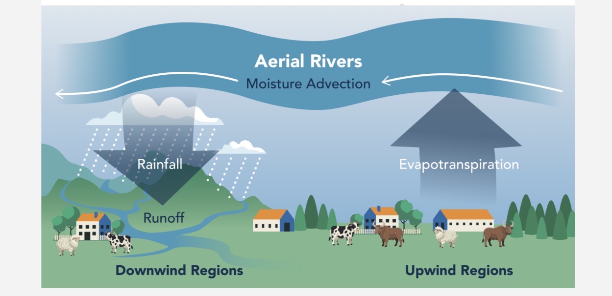
The researchers identified the continent's critical upwind basins, or dominant moisture sources that feed aerial rivers with water that seeps into the seas, evaporates from the soil, and transpires from vegetation as 'plant sweat.'
They also identified the so-called turning points beyond which the intensity of upwind moisture contribution to a particular region declines sharply.
Finally, they categorized and mapped the types of aerial rivers flowing over the South American continent, altogether tracing how far the rivers travel, how fast they flow, and how much water they discharge as rain.
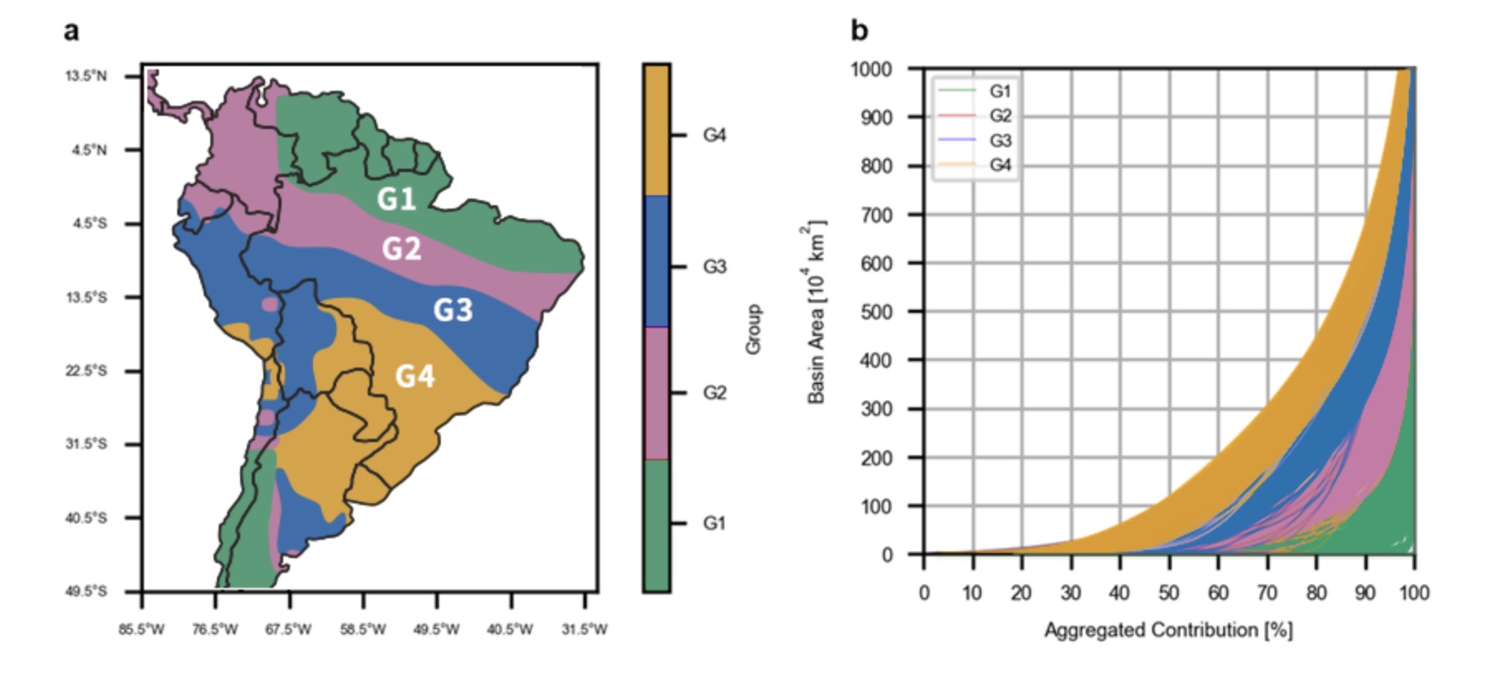
These drainage types facilitate diverse regional conditions.
G1 comprises the fluvial headwaters, or regions where aerial rivers enriched by the oceans enter South America, beginning the continental moisture transport. They represent the main entry points for moisture but are not limited to strictly coastal regions.
G2 regions act as fluvial drainage areas, where atmospheric drainage may increase, and water vapor may be lost as it travels inland.
G3 corresponds to fluvial outfall, where aerial rivers slow abruptly. Moisture content is markedly reduced, so these regions rely on continental evaporation to deliver rainfall. They stand to benefit significantly from water management since some may be situated upstream of major river basins.
G4, likened to atmospheric plains, may be located the farthest downwind. Unlike surface river plains, aerial rivers in these regions receive the least moisture, so they tend to harbor water-scarce cities.
Finding where water is most abundant, or needed, can therefore theoretically inform an entire continental (or presumably planetary) water management system.
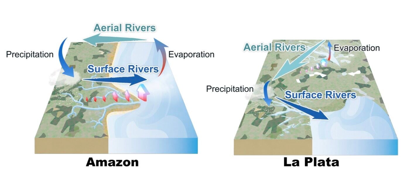
But tracking and managing aerial rivers is difficult due to their dynamically capricious nature: shifting winds can reverse the flow of moisture to coastal cities within a single day, the researchers note.
Additionally, many terrestrial variables can affect the recharging and discharging processes that govern aerial rivers.
Whichever way the aerial rivers flow, some conservation strategies are certain.
Forest preservation and reforestation are key management goals, especially in upwind basins, to boost the moisture content of the aerial rivers that will hopefully dump buckets of nourishing rain on the relatively parched lands.
"For instance, research shows that deforestation in the upwind regions of Peruvian Ucayali can contribute to a 5–13 percent reduction in annual rainfall and a 19–50 percent decrease in annual runoff in the region via aerial rivers," the researchers write.

This work also provides a systematic, mathematical framework for analyzing the impact of aerial rivers and their dominant upwind sources globally, highlighting the need for specific criteria rather than a one-size-fits-all approach.
But as with all Earth-saving efforts, ultimate water security depends on alliance, as "these basins often transcend administrative and topographic boundaries," the researchers explain.
"Their effective management requires institutional collaboration among entities responsible for regional governance."
Related: 'Tremendously Grave': The First US City Is on Track to Run Out of Water
Overall, quantifying and tracking moisture across continental scales offers a potentially invaluable tool to shape water management strategies worldwide well into an uncertain future, with the ultimate aim of reversing "global water bankruptcy."
"This highlights the importance of incorporating aerial rivers into water management frameworks," the researchers conclude.
This research was published in Nature Communications.
This article was fact-checked by Clare Watson and edited by Clare Watson. While we pride ourselves on our process, we are only human. If you spot a mistake, please let us know.